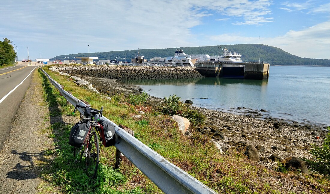
 Top: Ferry terminal, Digby, Nova Scotia; Bottom: Elevation profile Digby to Bridgewater, 30 August 2019. 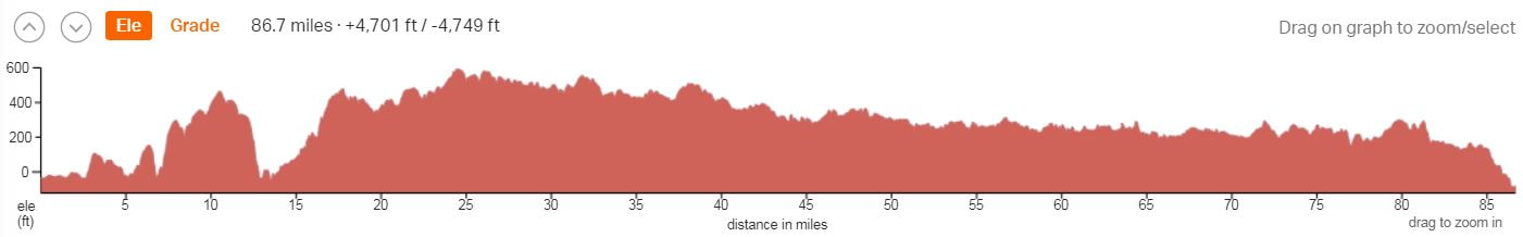  My route from Fredericton, New Brunswick (not shown on map) on 30 August to Saint Johns where I caught a ferry to Digby, Nova Scotia and then bicycled to Middle Lahave; and the next morning to Halifax, 31 August. I've included my departure routes form Halifax for perspective, my next blog entry will cover Halifax to North Sydney. Background: This is the fifth blog entry, the first a prologue, in a series that when completed will tell the story of my 2018 autumn cycling tour through New England (United States) and eastern Canada including Newfoundland and Labrador. Please scroll down this page to read the story in the order that the events occurred starting with my arrival to Maine on 10 August 2018 described in the prologue, Going Full Tilt to Newfoundland and Labrador. As much as I try to avoid commitments on my adventures, preferring instead to fly-free whenever possible, occasionally a commitment arises by design or necessity that requires me to be somewhere on a particular day, and perhaps time as well, for a rendezvous with some-one, or some-thing, such as a ferry boat. This tour had more than it's share of commitments, much more than any of my previous explorations by boot, boat, motorcycle, or bicycle. Most involved friends ... ... and visits that occurred earlier in the tour, in Maine and New Brunswick. You'll find those details in previous blog entries in this series. All of these visits were low stress, easy, and flexible. These sorts of commitments could add years to a travelers life. Similarly, as I've mentioned elsewhere in this series, ferry crossings can also add significantly to any adventure and I encourage readers to literally seek them out on their own trips despite the commitment and any associated stress that might arise. Understandably, ferry boats that cross wide-expanses of ocean, as opposed to (e.g.) short river crossings, are never flexible, always coming and going on a strict schedule with limited departures, perhaps as few as one time per week. Of course, a cyclist is required to arrive, same as the other passengers, on schedule despite what can go wrong and ultimately slow them down on any given day. And their arrival must also compensate for time to board and securely stow their bicycle on the car deck, usually by lashing the bike with the most desperate rope you can imagine but nonetheless sufficient for the job. The first of three significant ferry crossings I planned for this tour was a transect of the Bay of Fundy from Saint John, New Brunswick to Digby, Nova Scotia, about a two hour journey. Once in Digby, I was hoping to reach, by pedal power the same day, a small, undetermined village on the Atlantic Coast. I was anticipating the days ride would encompass most of a hundred miles and take roughly seven hours if I was able to maintain my preferred 15 mph touring pace. To maximize my chances of reaching the Atlantic, and the next day a friend's home in Halifax, I had to be sure, a commitment with significant implications if I missed it, to catch the eight am departure from Saint John rather than the much later 2:15 pm ferry. Plans were made and remade a few times during my second visit with the Whiddens the evening before I departed Fredericton. When the process concluded, a friend, one of Tony's students, volunteered to pick me up at sunrise and transport my bike and body to the ferry terminal in Saint John. The drive, most of it on Route 7 at highway speeds, takes about 1 hr and 15 minutes. To bicycle the same would have required a minimum of 4 hrs 15 minutes, assuming a 15 mph average pace. As these numbers imply, to catch the eight am ferry by bike, I would've been obligated to depart Fredericton by no later than three am with lights and flashers blazing most of the way to the dock. I sacrificed a little purity on this bicycle tour by integrating an internal combustion alternative but sometimes these sacrifices are necessary to achieve a goal that should, in the end, receive no lasting, ill effect from such a small deviation from my core conservation values. Fooled by signs that led us most of the way to the wrong ferry crossing before I realized my mistake, Lauren Scopel and I nonetheless arrived to the proper ferry and ticketing building with about five minutes to spare. I dashed inside, somewhat frantically dislodged my credit card from my wallet, a hair-tie that I picked up in a laundromat a few months back, and then, a moment later, dashed again to Lauren for a quick hug and goodbye before I descended down the steel passenger slip to the car deck and the inner bowls of the ferry boat. Along the way, ferry personnel encouraged me to make haste and I obliged them as I jogged alongside my loosely packed bicycle, down stairs and other obstacles. Amidst these realizations of unanticipated, by the author, haste and flurry, but no doubt supervised by the playful universe with it's characteristic deep-set grin, the next phase of my tour was underway, and my heart was getting a proper warm-up for what would be, in hindsight, a very memorable day of cycling across Nova Scotia from the Bay of Fundy to the Atlantic Ocean (see map above). The municipality of Saint John, New Brunswick was founded by a charter issued by King George III in 1758, just two decades after the death of Sir Isaac Newton (1642-1727) and a half century before the birth of Charles Darwin (1809-1882). At that time, Saint John was the only incorporated something in what would become, eventually, Canada, getting the jump on communities as well known historically and today as Montreal, Winnipeg, Vancouver, and Quebec City. Like much of this part of Canada and adjacent Maine in the United States, the land associated with Saint John was in near constant dispute for many decades between France and Great Britain. Amidst these disagreements involving far-away kings and disconnected generals, a small group of American loyalists (to the UK) and a much larger group of desperate Irish immigrants also contributed to the history of Saint John:"Saint John, as a major settlement, was established by about 3000 refugees of the American Revolution in 1783 when two fleets of vessels from Massachusetts arrived in the harbor These Loyalists were forced to leave their U.S. homes during the American Revolution (1765 – 1783). In 1785, the municipality became the city of Saint John. Over the next century, waves of Irish immigrants, namely during the Great Famine via Partridge Island, would fundamentally change the city's demographics and culture.." Despite the city's significance for Canada as a the "third largest port by tonnage", Saint John nonetheless experienced a population decline for four decades, 1976-2016. Since that time, Saint John has become the second most populous in the province and upgrades to infrastructure, the arts, etc, have all followed. Although my schedule did not allow for a visit to the town center and sites, including Reversing Falls Gorge and the Loyalist Trail, readers that pass through the area should consider a tour of this historic community. After stowing my bike for the journey across the bay, I clicked my way up several flights of stairs, a pannier in each hand, to the upper decks of the Fundy Rose, a massive vehicle and passenger ferry. Inspired by a commanding view of Saint John Bay and the adjacent city rising above the sea on hills representing the Caledonia Highlands, I experienced an upwelling of excitement reminiscent of my "swamp exploration" days, an excitement inspired by the same part of my brain that once was the source of an enviable, untarnished childhood naivete. Close by, on adjacent piers, cargo ships were being unloaded by cranes that reached skyward to impressive heights. Below the cranes, islands of shipping containers, stacked five and six deep in parallel rows, awaited the trucking industry that spelled the conclusion of Fredericton's former rail system. These distractions filled my thoughts until the Fundy Rose slowly backed-away from terra firma and turned her bow, and my gaze, towards the Bay of Fundy where she initiated a south-southeast transect that concluded in Digby, Nova Scotia. The hydrology of the Bay of Fundy is so unusual and equally impressive that it's hard to focus on any one of its watery statistics in particular. However, one stat arguably stands out, the 100 billion tonnes of water that flow out of the Bay twice daily into the Gulf of Maine. A quantity that is, quite shockingly, equivalent to two-times the combined total daily outflow of all of Planet Earth's rivers! With so much water in motion, a follow-up question, about energy production, naturally begs exploration. And it turns-out that the energy produced by each inflowing or outflowing (also twice a day and 100 billion tonnes) tide is equivalent to the power generated by "8,000 train engines or 25 million horses"! I always try to minimize flair in my writing, including minimal use of exclamation marks. This was one of many valuable lessons taught to me when I was being mentored as a science writer by my PhD supervisor, Tony Diamond. But I think Tony would agree, the two statistics just given are each worthy, preferences aside, of a concluding exclamation. And here's another worthy candidate that pertains to hydrology and the Bay of Fundy: water flowing back into the Bay creates a tidal bore (a wave) in some cases two meters (6.6 feet) high as it pushes-up against freshwater that is attempting to flow downstream from rivers like the St. Croix and Petitcodiac. These tidal bores are so spectacular that a group of surfers naturally took note and in 2013 successfully rode a tidal bore on the Petitcodiac River a record-breaking 29 kilometers (18 mi). At this juncture in my travelogue, it does seem an unfair conclusion, for the athletes on their surf boards in particular, not to insert an exclamation. The view from the upper decks of a ferry boat for spotting marine life provides a considerable vantage relative to the view from shore or an otherwise preferable combustion-free kayak. To maximize my ability to spot and identify wildlife, I was carrying my aged, 1998, Bausch and Lomb Elite binoculars specifically for this crossing and two others which I'll write about in forthcoming entries. During the Bay of Fundy crossing, I was hoping to get a glance or better of a little known visitor to this latitude, primarily during winter months, the dovekie or little auk as it's known in English, smallest among the Family Alcidae, a family of birds that are adapted to living in marine environments. Despite it's diminutive size, its length close to the average size of the human hand (7.44 inches) and weight equivalent to less-than half a deck of standard playing cards (ca. 1.7 ounces), the dovekie is a distant relative of one of the largest land predators so far discovered by Paleontologists, the Tyrannosaurus rex. From a distance, the dovekie is a fairly typical black and white seabird, but up close I think everyone would agree that this wee bird certainly qualifies as a worthy representative of Planet Earth's charismatic mini-fauna. The dovekie raises its offspring, during summer months, in large colonies on islands above or just below the Arctic and its defining circle, ca. 66 degrees north latitude. The southernmost colony is not far from Nome, Alaska, just south of the Chukchi Sea in the Bering Strait. Within the Atlantic quadrant of the northern hemisphere, the species breeds as far south (exclamation worthy) as Baffin Island. If you have no idea where snow and ice covered Baffin Island is then I suggest clicking on the link and taking a tour on Wikipedia. Across Baffin Bay, eastward, modern explorers, perhaps you among them, will also find the seemingly fragile, for its size, dovekie breeding in large colonies on the periphery of Greenland. Between breeding seasons, the species reliably wanders as far south as the Bay of Fundy and even Cape Cod, Massachusetts, in search of more temperate conditions and it's preferred food, small marine invertebrates including amphipods and copepods. Sadly, but it was a long shot after all, I did not encounter any little auks on this crossing and the species remains, up to this writing, a stranger, despite my wide-and-far travels and completion of a PhD on the ecology of a related species, the poster-child of the charismatic mini-fauna, the Atlantic Puffin. Two hours on deck occasionally scanning with my binoculars for local biodiversity was enough to settle my mind into peaceful meditation, inspired by the constant movement of the sea around me, a comfortable breeze, and a not-so-bad coffee purchased inside the Fundy Rose. Occasionally interrupted by serendipity, such as the spout of a nearby minke whale or a school of Atlantic white-sided dolphins playing in the ships wake, I reflected on my tour to date high up on the decks of an anonymous ship floating above a sea that is connected to all of the World's oceans and the creatures that live there. So far, the tour had produced much more than I had anticipated. Among my collected treasures, by now, were quite a few encounters with friends and strangers that would keep me feeling as if I was never alone on this otherwise solo, bicycle tour across wide expanses of lightly populated areas in New England and eastern Canada. And places easily filled the spaces between, rivers and hills, farm tracks, etc, so much so that the whole was already a tapestry worthy of an enviable adventure. When I disembarked from the Fundy Rose, I would initiate the next phase of my tour, an impressive transect of Nova Scotia, first from ca. west to east, Digby to Halifax, and then from south to north, Halifax to North Sydney. In the meantime, unaware of my destiny, I smiled with anticipation of what I might experience in the next two days (Digby to Halifax) as the captain navigated the Digby Gut on approach to the ferry terminal in the Annapolis Basin. Caffeine and an enviable view can accomplish many things but they cannot warp space-time, or the ambition of a bicycle rider to set forth on the next phase of his bicycle tour. Digby, Nova Scotia was founded in 1783, the same year that witnessed the conclusion of the American Revolutionary War (1776-1783). From the busy terminal, after a quick photo (provided above), I pedaled away from the remarkable Annapolis Basin, for the safe anchorage that it offers to sailors and their kin, and made my way south on Route 303 to Conway, where I crossed under popular Route 101 and then transitioned onto Acacia Valley Road. As I approached nearby Acaciaville, bike and rider seemingly plummeted (see elevation profile above), back to the edge of the sea, to an inlet known as Big Joggins. Not far beyond, I turned left onto a little known, other than to locals and postal workers, dirt road named Lansdowne, and soon faced a loose gravel ascent that challenged my lungs, legs, and drive-train. Once back on top of the province, Lansdowne delivered me eastward about five flattish miles to the picturesque, coastal community of Bear River, a village built on both banks of its namesake waterway above a tidal cove. Most of the buildings were covered in cedar shingles, rarely stained, the locals seeming to prefer natural wood and weathering in shades of grey, punctuated by green, yellow, and orange pigments contained in the leathery skin of colonizing lichens. Amidst this charming community, I couldn't resist a short out-n-back onto Bear River's central causeway and along the way take a quick tour of the town. The tide was out when I arrived and as a result the local fishing fleet lay comfortably on terra firma a handful of meters below the top of the town's piers. A twice daily occurrence that reliably produces the signature scene along the Bay of Fundy coastline captured by story-tellers and photographers for generations. From the middle of the causeway, I backtracked to Bear River Grocery and turned left onto River Road. The next few miles were enviable, scenery and solitude, including another steep ascent, a wall, out of Bear River. At the top of the hill, I rolled along at a casual pace on the forested south bank of a river that moments before was a stranger but already was filling my heart with feelings reserved for friendship and the comfort that often comes with those relationships. Not far from Bear River, River Road split into three paved options including a continuation on River Road itself. Three options withstanding, at his juncture, my GPS pointed me towards a fourth option, closer to the river, a conclusion I resolved after riding up the previous three, each time watching as my position on the GPS gradually departed from my intended route. Despite its presence on maps integrated into RideWithGPS, a internet-based route building tool, the fourth option remained hidden for about five to ten minutes as I went searching this way and that way, puzzled by the juxtaposition of the three tracks on my Garmin eTrex20 screen amidst a fourth that did not, otherwise, seem to exist far, far below a few guiding satellites in lonely, one would assume, medium Earth orbit. On what was likely my fourth or fifth pass by a worn-down, concrete something, that did not reveal its former purpose on the south bank of Bear River, I decided to have a closer look and only then discovered a very discouraging two-track that plunged into the forest (see image below). Even worse, a sign on the right, above this seemingly forgotten road, read "No Road Maintenance, Proceed At Own Risk." When faced with the road less traveled, among a few also known as "Keppie's Path" in reference to Dr. Daniel Keppie, retired professor and one of my principal mentors in graduate school, no matter how loud the warnings and proximate the alternatives I have inevitably, nearly 100% of the time, chosen the less traveled path. And not just in my adult life, the same was true when I was a youngster and in all instances I believe the habit has given much more than taken away. Such was the case when I remounted my bike and pedaled into a setting that could have inspired Sleepy Hollow and the famous headless horseman that animated the childhood fairy tale. Just beyond the entrance, a tree tunnel that led me into the woods, I came upon the first of two dilapidated, wooden bridges over the river, which at this juncture was shallow yet full of energy, white froth bubbling-up here and there as the river moved around and between rounded stones no doubt deposited as outwash from the melting Laurentide Ice Sheet 10,000 years ago. Bike and rider weighed ca. 200 lbs, not much for even the most desperate of bridges. Nonetheless, the sight of the bridge inspired caution and so I respectfully tip-toed my way from the south bank to the north, without incident. Beyond the first bridge the rough two-track road steadily degraded. Tree limbs encroached over my path, dense non-woody plants concealed a surface armored with embedded stones, and large and small branches deposited by the overhanging canopy onto the road added to these challenges. When I arrived to the second bridge, I repeated my cautious advance and then did my best to ride on. Caution withstanding, with each passing moment, by now my mind and body awash in the sound of flowing water, bird song, and the familiar smell of a North American deciduous forest, my anxiety steadily declined, and by the time I returned to a consistent road bed I was grateful that I'd made the choice to follow Dan's precedence. Not far beyond the second bridge, the road surface improved, considerably and that comforted, a moment too soon it turned out, any lingering concerns about bike and especially tires. This section, beyond the dilapidated bridges, was being accessed from the east (versus my route) by a handful of landowners and there were signs of further development underway, including crude roads recently hacked out of the forest. But despite improvements, vast relative to where I'd just been, this unnamed track was mostly surfaced with loose, half-inch gravel identical to what's used to bed railroad ties, a nightmare for a cyclist rolling on 28 mm tires. I did my best to stay on the hardest bits of the road but eventually I experienced a near-flat following an undetected impact with a sharp chunk of gravel. A near-flat is a flat that does not quite deflate the tire completely, this is not unusual for tires and rims mounted without tubes. Between the rim (or hoop) and the tire a sticky sealant, ca. four ounces, by design explodes out of any breach and generally, depending on the damage, seals the problem. My hole was big enough that I had to stop a few times to add air to the tire. In hindsight, I should have taken the time to install a tube, the only option when the hole will not seal. By not doing so and whilst rolling on a partially inflated tire, I added a fair number of dings to my Stan's NoTubes Grail aluminum rims as I negotiated and banged up against the graveled surface. Eventually I came to a dam, under construction, waved to a few surprised workers, and then took a left onto a quality, hard packed, dirt road. Sam Harris Road led me to Greenland Road then Victory Road which I followed, after a memorable incident, for many miles all the way to Route 8. My recollection is all but a short section of Greenland Road was dirt. As I approached the right turn onto Victory Road, a nightmare that I often think about, and occasionally experience, got underway with no warning, there never is one. Understandably, people that live along rural routes often think a lot less, or perhaps care a lot less, about tethering their dog(s). In the majority of cases, the dog(s) in question are not life threatening and any incident quickly subsides along with the riders heart rate and associated spike in adrenaline. These non-threatening occurrences certainly rattle nerves but they pass quickly into forgotten memory in contrast to encounters that involve a threat to limb or even life. When the scenario is life or limb, it's not unusual for the offending beast to be a female pitbull, at least that's been my experience. The regularity has been such that even when I'm introduced to a seemingly well behaved and cared-for pitbull, male or female, it's a struggle for me to completely dissolve my discomfort. An obvious swerve (see map image below) along an otherwise straight GPS line that I was recording (Garmin 520) as I rode along Greenland Road marks the moment in my awareness that a dog was quickly approaching. I regained my initial track but then only for a second or two before the track became a series of many overlapping circles. By this point, I was off the bike and fending off a white, spotted, snarling, barking, and lunging female (imagine lots of nipples) pitbull. Within a minute or two, her owner was also on the street and doing her best to try to get her hand on the dogs collar. This went on for what seemed like five minutes. In the meantime, I grabbed a water bottle off the bike which I hoped would be enough, if I sprayed the dog in the face, to postpone a bite a little longer. But the bike proved to be a sufficient barrier at least in time for the owner to finally contain the dog. Unlike far less threatening encounters, attacks like this one will rattle your cage for many hours, as the biochemistry released by your body's various glands and organs are slowly dissolved by much slower biochemical processes and reactions. This is particularly significant when a person will, subsequently, be relying on their bodies reserves, carbohydrates, vitamins, etc, to accomplish a difficult athletic challenge. When the attack occurred, I was less than twenty miles into a ca. 96 mile day. By the time I reached Route 8 at mile thirty, my nerves, mind, and body had seemingly returned to normal. But I have no doubt that this was a delusion. In reality, impressions of our superficial mind withstanding, an incident like this violent attack no doubt continued to tap into my limited resources for the next twenty-four hours and maybe beyond. What I experienced could be described as a short bout of post-traumatic stress disorder with all of its implications, a big price to pay because someone decided, mindlessly or consciously, that their dog was not a threat to people passing by on a public road. Following words of wisdom and patience, I gradually rolled away from the incident and took a right onto Victory Road, feeling less than victorious but still much better than I had a moment before. The sounds and smells of the forest beckoned with each passing mile and soon I was enjoying my favorite pastime as much as I had been when I rolled onto Greenland Road. Unbeknownst to me, because these wetlands were obscured from view, I passed by Charlotte and Simpson Lakes; and about the same time, lakes of about the same size known as Lower and Upper Mink. South of Big and Small McLellan Lakes, I pedaled back onto the pavement and turned east onto Route 8 towards the podunk town of Maitland Bridge, where a nameless creek passes by on its way to nearby Kejimkujik National Park and the full suite of businesses, according to Google Maps, are Automotive Dorey and EJ's Grill & General Store. A dirt track headed north out of Maitland Bridge and I intended to follow it, somewhat reluctantly by now given the incident with the pitbull. With that incident in mind and hoping for a bit of confidence, I asked the girl, a youngster, working at the General Store about the road, "rough, gravel, etc?" But she didn't have much to say, good or bad, I resolved to face whatever challenges awaited me and rode onto the dirt whilst still chewing the bounty I'd recently acquired from EJ and his kin. I was contemplating something from the Grill but instead settled for the General Store which turned-out to be about as desperate as they come, seemingly all manufactured (processed) foods. I circled the displays several times before I concluded on mixed nuts and a jerky, neither are healthy options but my mind enjoyed them nonetheless. The surface of Northfield Road heading initially east out of Maitland Bridge varied quite a lot, including short sections of pavement but mostly quality gravel. Surfaces aside, it was lightly trafficked, a bonus, and as such a pleasure to explore on a gravel bike including my Niner Bikes RLT Steel. Along the way, I passed by Pretty Mary Lake before I transitioned left onto Mill Lake Road. Form Mill Lake, I turned right onto Delong's Crossing, a short stretch that delivered me to the center of New Albany, a town so small that there wasn't a downtown in sight. A few miles farther on I turned off of New Albany Road onto Rossette Road, heading east-southeast. Signs of the inevitable abounded as I rode the first half-mile on Rossette. Maples and birch closed in and the road gradually narrowed. Soon potholes transitioned to deep ruts side-by side with stretches of exposed, granite bedrock (see image below). Some of the holes were full of water. There were summer camps here and there, but otherwise all signs suggested this was a recreational road used primarily by four-wheeled, thumb throttled, crotch rockets. Despite backing way-off on my own throttle, a pair of partially covered legs, quite hairy, and by now quite dirty, I still managed to cozy up against a few blunt somethings over the next several miles. And worse, the bike and I were constantly being jostled as I swung from trail left to right, and back, to avoid mud holes and other obstructions. I didn't know it at the time but this would be almost, not quite, the last bit of thrashing before the welds holding a mounting pin on my rear frame cracked and with it a critical attaching point for my rear rack. As much as I love the parts of any adventure that require mental and physical toughness, because these moments give the most back, the day was already witness to many challenges. Combined with a late start, 10-ish am, I was naturally, by this point, feeling some fatigue. But I had one more challenge to overcome, apparently, close to Hen Lake on rough gravel where I smacked an invisible rock and immediately listened to the air quickly spill from my tire along with all 4-ounces of the sticky sealant manufactured by Stan's NoTubes. Feeling somewhat defeated, I looked around for a soft patch to install a tube, a grassy patch above the lake was sufficient. Nearby, I also found a perfect branch for hanging the bike by its saddle. I took the time to eat a snack before doing the job, no doubt that uplifted my carbohydrate depleted brain a fraction and soon I was on my way again. I followed Rossette Road for many miles. At its conclusion, I returned to asphalt in North Brookfield, much welcomed even if the RLT could not speak, and took a left onto Route 208 just before the village church. About a mile farther along, still rolling on a partially inflated rear tire, I spotted an old timer hammering away at an old trailer just outside of a big red barn. I turned immediately onto his well manicured lawn and called out to him as I crossed a wide-expanse of enviable green grass. Unfortunately, he didn't have a fitting for his air compressor to accommodate my euro-style Presta valves and so I enjoyed a few minutes of conversation with a local before resuming my northeast trajectory on Route 208. Route 8 led me to Route 325 which I followed, southeast, without further incident as the time-of-day dipped into its first hints of early evening all the way to an Atlantic Superstore in the populous town of Bridgewater. Significantly, for my ambitions, Bridgewater is bifurcated by a tidal section of the LaHave River, evidence that by reaching Bridgewater I'd also accomplished my goal to cross Nova Scotia from the Bay of Fundy to the Atlantic in a day, with a tale to tell involving many mishaps and other challenges along the way. My habit on bicycle tours to date has been to book lodging, typically a private room with a shared bath, at around five pm each day using AirBnB's smartphone app. Conveniently, the app includes a map feature that identifies the location of each option and the price. Using filters it's easy to fine tune the results, a process I repeated under a projecting roof outside of the Atlantic Superstore as a well timed rain otherwise drenched the parking lot and any nearby cyclist not as fortunate as me. In a few minutes, I was booked into a private room in a home downstream of my location, a community known as Middle LaHave on the north bank of the LaHave River. Thirty minutes later groceries for the evening and the next morning were stowed in my panniers. I took my time closing the gap from town to bed along a scenic nine, lightly trafficked miles that added to the 87 miles I'd ridden earlier in the day. When I arrived to Middle LaHave, I found Mike, the innkeeper, cutting his lawn. He directed my bicycle to a cozy corner in his mostly empty garage. After a quick tour of the house, I quickly moved on to eating everything in sight, an inevitable conclusion to a long day of self-propelled touring. Below I've inserted an image of the bedroom where I spent the night, for 23$ plus fees which were minimal at this location. In addition, you'll find images of my bike leaned-up against a beautiful old tree in his front yard; the deck where I enjoyed a coffee the next morning is also in clear view. The image of the LaHave River was captured in morning light whilst standing on a guardrail post across the road from Mike's home. The scene from any of these perspectives was impressive, set amidst a community that prioritizes solitude and the sounds and smells that accompany that reality. I could have sipped coffee on Mike's porch for many mornings and listened to him recall stories about the antiques decorating his home, including the bed that I slept on. Instead, given my ambitious goals, I was on my way again the next morning, at roughly nine ante meridiem. Within minutes of my departure, I felt an unnatural sway coming from the rear portion of the bike. I stopped to inspect and discovered a near-worse case scenario. The welds holding the rack pin to my bike frame on the left seat stay had cracked. Each time I pushed down on the pedals the rack and panniers shifted a little left, then a little right, and if I wasn't careful the sway picked up momentum. In the fourth entry in this series, I describe how the problem came about, involving poorly designed Blackburn panniers (kudos to them for quickly refunding my money after the trip). But it's worth rehashing at least where the problem started, a rough section of Stud Mill Road, for details see the third entry in this series. That thrashing was compounded by the Nashwaak Trail between Fredericton, New Brunswick and Stanley, details are provided in the fourth entry in the series. Lastly, by the unnamed road close to Digby and more significantly by Rossette Road, equivalent to a jeep trail in other parts of the world where jeeps abound. Sources aside, at present I needed to do something about the break. I temporarily rigged a rope fix and went in search of a welder, Not far down the road, a couple of fishermen directed me to ABCO Industries in the nearby, historic and quite scenic, village of Lunenburg, Nova Scotia. Lunenburg is a World Heritage Site, "UNESCO considers the site the best example of planned British colonial settlement in North America, having retained its original layout and appearance, including wooden architecture." Established in 1758, "the town was one of the first [outrageous] British attempts to settle Protestants in Nova Scotia [where they] intended to displace Mi'kmaqs and Acadians." As I went in search of ABCO Industries, I eventually ascended an inconspicuous hill, approaching Lunenburg from the south, on a section of Masons Beach Road. It was a behold (!) sort-of moment at the summit, spread-out below was the famous village of Lunenburg rising on natural earth benches above Lunenburg Harbor. Among a handful of proximate misses from my tour, a chance to visit the central village of Lunenburg, which I bypassed, easily comes to mind. Instead, at the top of the hill, despite the enviable view, I remained focused on locating ABCO and determining just how screwed I was, or was not. Not far from the descent of the hill I arrived to ABCO, overshot it, turned back, and a moment after was talking with one of the facilities supervisors. I explained the purpose of my visit including the break and the fact that the bike was steel, the least fickle among metals when it comes to welding. It's worth a quick pause here to stress the value of touring on a steel bike: if a mounting pin or worse, the frame, cracks for any reason then welding options and welders to operate that equipment will be in surplus in most parts of the world. I don't recall the fella's name but despite some reluctance, initially, he agreed to walk the bike back to one of his welders and inquire about what was possible. Thirty minutes later, savior and bike returned, with a fresh weld on either side of the internally threaded pin. The welder used a method known as brazing, a technique that heats but doesn't melt the base metal, in this case the bike frame. In my mind, the issue was resolved and I was relieved to an extent that I cannot be describe in words. Although that turned-out to be a false assumption, I nonetheless rode on with confidence after thanking the welder, indirectly, and his supervisor directly. I spent the remainder of the day on and off converted, rail-to-trail, bike paths as I made my way eventually to Halifax, the capital of Nova Scotia, a total of 76 mostly comfortable miles under enviable, partly cloudy skies. Sections of the trail were very rough, similar in surface and discomfort to the Nashwaak Trail. Well aware, by now, of the significant issue with my bags and rack, I often chose to hop off and then back onto the rail-to-trail system as I made my way east and a little north, attempting to avoid the worst sections. But despite my awareness and sympathy, the latest welds were no doubt already being stressed. Nonetheless, a warm, sunny day filled me with bliss as I explored this part of Nova Scotia's coastline. Along the way I passed through many more scenic villages, including Martins River, East Chester, and Boutiliers Point. Once past St. Margaret's Bay, I descended, seemingly glided, east-southeast into Halifax. The last few miles were on exceptional rail-to-trail, surfaced with hard-packed pea gravel. I've inserted two images below from this section of my tour. As day was just beginning to give way to night, early enough that the sun was still shinning on parts of Fairview Lawn Cemetery, I arrived at the final resting place (image below) of no fewer than 100 victims of the R.M.S. Titanic disaster, an event that shocked the world when word of the sinking, early in the morning of 15 April 1912, slowly arrived by word-of-mouth and available technology. Walking slowly between the rows, I read the graves, many anonymous, a few marked the conclusion of children including at least one infant. There are few places amidst the constructs of human society that provide as efficient a path to gratitude as our graveyards. In my travels by boot and motorcycle in my twenties and thirties, I don't recall a habit that I certainly have now of looking deep into cemeteries and myself simultaneously. Perhaps this is a habit brought on by proximity to my own conclusion. But I prefer to hope instead that my habit of peering curiously and reflectively into our stone-studded sanctuaries for the dead comes from living a large part of my life with eyes wide open, for my own good and for the good of others, a habit that I've refined on my bicycle tours. After quality time to reflect and be grateful in this famous cemetery amidst so many tragic endings, I used my Android Motox4 on Google's Fi Network to search for a local bike shop before departing the non-chaotic, quiet, etc, privileges of a graveyard. I read a few Google Reviews and decided to visit Cyclesmiths on Agricola Street close to downtown Halifax. Without a convenient way to either mount my phone or punch an address into my Garmin eTrex 20 GPS, I did my best to memorize the few turns between here and there and then set-out onto the busy streets of Halifax, by now in full evening commuter mode. About twenty minutes later, or thereabouts, I happily turned left off of busy Windsor Street into a relatively peaceful neighborhood, suburban in character despite it's proximity to downtown Halifax. Massive trees lined both sides of the road creating a cool, comfortable environment for anyone enjoying the open space below by foot or bicycle. I lazily rolled east-northeast along Willow Street, enjoying the last few miles as I often do with deep reflection accented by smiles and sometimes even audible laughter. In this enviable state of mind, a moment later I arrived, unexpectedly if you can imagine, to Cyclesmiths and soon I was engaged in conversation with a mechanic about a new set of tires, a chain, and anything else he determined the bike might need after an inspection. I spent quite a few minutes trying to decide on which tires to purchase, ultimately choosing a set manufactured by René Herse Cycles, formally Compass Cycles. Jumping ahead in my story, these turned-out to be an exceptional tire on all surfaces. I have to guess by this writing which model I purchased, but I believe it was this one, their 700 cc x 28 mm Chinook Pass model. By now I'd ridden about 1200 miles since arriving to Bremen on 10 August and departing about one week later to start, officially, my autumn tour. Along the way, I'd worn-out my chain and tires, on schedule even though my tires experienced an exceptional beat-down on sections including Stud Mill Road in Maine. Because of those beat-downs in particular, I was also rolling on a tube in the rear and was eager to return both wheels to a tubeless set-up, just a tire, Stan's NoTubes sealant, and a rim. The absence of a tube allows for a wider range of tire pressures, especially lower pressures, since there's no risk of pinching tube against rim causing a "pinch flat." Rolling tubeless also contributes, plus two, to the question: how many flats can a cyclist experience before they're out of options? That is, walking or hitch hiking. I was carrying two tubes on this tour as back-up, one for each wheel. A double-flat is rare on any given day, and more than two is associated with a minuscule probability, so two tubes as back-up when rolling tubeless provides a high level of assurance even when exploring the periphery of available infrastructure such as rough gravel roads. Eventually, I handed-over a pair of Compass Tires to a busy mechanic and we quickly concluded that I'd pick up the bike the next day, not long before the shop closed. By this time, a good friend from my graduate school days had arrived to Cyclesmiths and he was keeping me entertained, as usual; it was as if only a moment before we were sharing the halls and other spaces in Bailey Hall high above the Saint John River in Fredericton, New Brunswick, despite years gone by between that life and the here-and-now. From the shop, we retraced a part of my journey from Fairview then overshot a few miles to his home on the periphery of Halifax. Saranyan's family greeted me with laughter, especially from the youngest two members of his family, and warm greetings from his wife Lavi, also a friend from my time in Fredericton. Lavi had been busy preparing a traditional Indian meal just for my arrival. Once assembled at the table I took instruction on how to eat, like the family, with two fingers and opposing thumb on my right hand. It was the sort of meal that travelers sometimes experience and always celebrate: friendship, culture, flavors, conversation, and a playfulness that blurs the edges into a surrealist's imperfect vision of beautiful human relationships. In my next entry, I'll share some of my visit with Saranyan, including a social drive and exploration out to Peggy's Cove, a famous, exceptionally small despite its popularity, village at the end of the peninsula that abuts St. Margaret's Bay to the north and east. This story includes one of the most impressive post-glacial scenes that I've encountered in my lifetime. The following morning, I'll take you with me as I ride over the monumental, steel, Murray Mackay Bridge that towers over Bedford Basin and the whole of Halifax, then onto the Trans-Canada Trail, across Cole Harbor Marsh and beyond into more drama, another welder, and ultimately North Sydney, Nova Scotia, where I was scheduled and did manage to board a ship, on time, for an overnight passage to Argentia, Newfoundland.  The road less traveled and my first clue, 'no maintenance ...', that an alternative route was likely advisable. Likely within the borders of Bear River, Nova Scotia, not far from the much more civilized River Road, 30 August 2019. 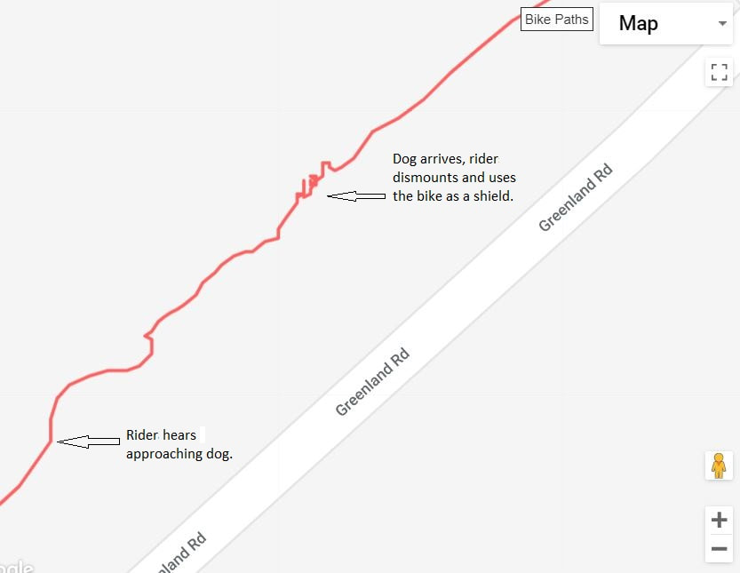 The evolution of a dog attack, a female pitbull, from detection, initial swerve marked on the map, to defense using my RLT as a wall, circles also marked on map. See text for details, 30 August 2018. 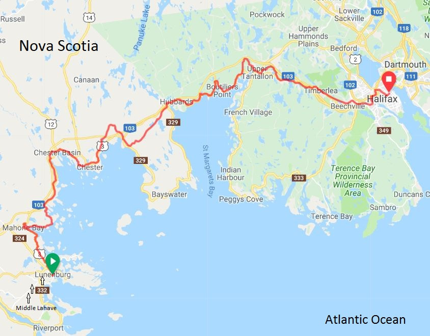 My route from Lunenburg to Halifax, Nova Scotia on 31 August 2018.  Somewhere on Rossette Road between Northfield and North Brookfield, Nova Scotia, 30 August 2018. 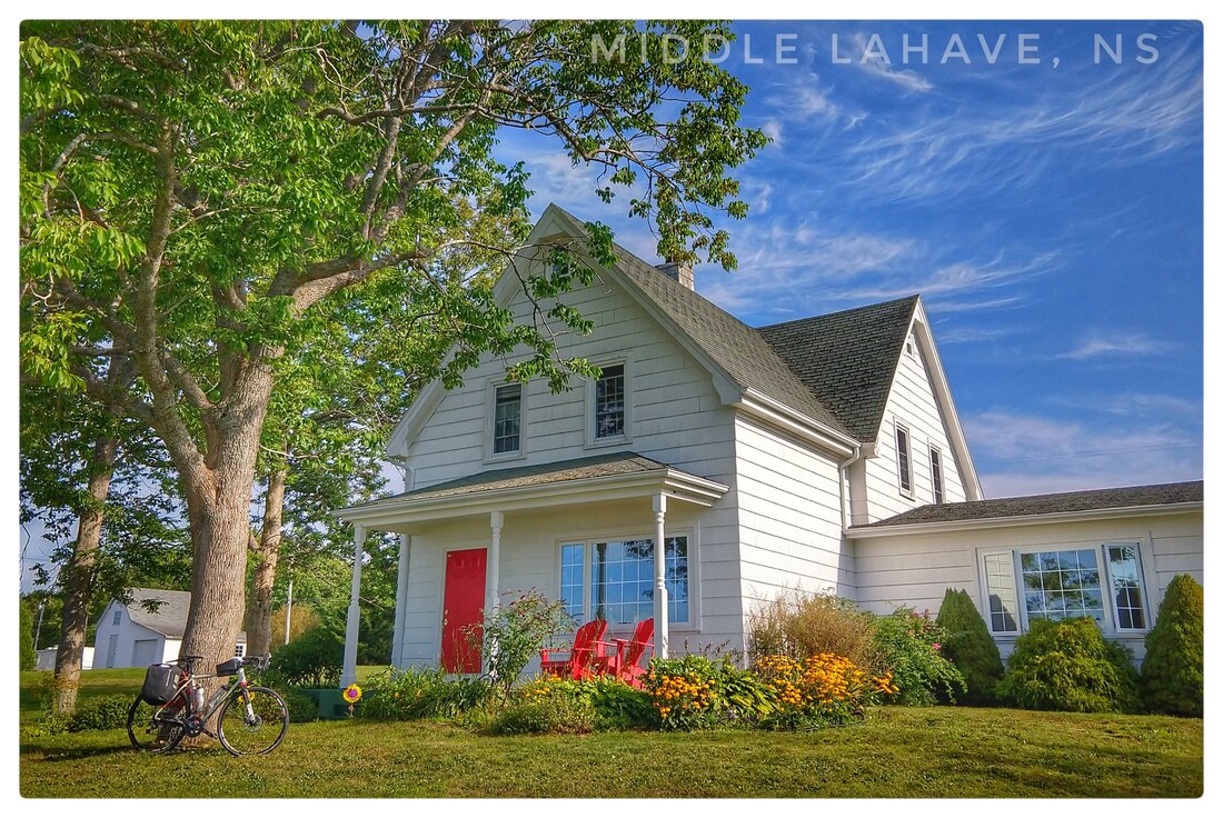 Mike's AirBnB in Middle Lahave, Nova Scotia, above the Lahave River, 31 August 2018. 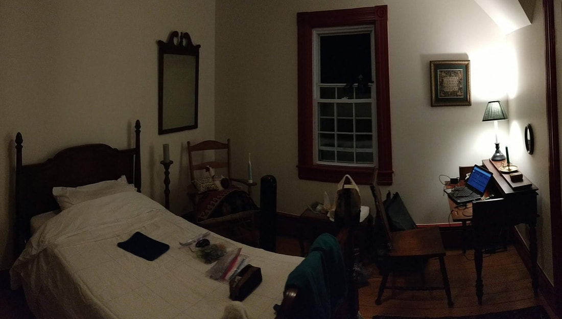 Lodging on the cheap amidst antiques including the bed and writing desk in Mike's AirBnB, Middle Lahave, Nova Scotia, 30 Aug 2018. 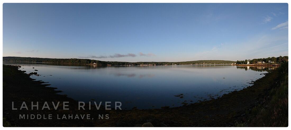 View sipping coffee from Mike's porch, Middle Lahave, Nova Scotia, 31 August 2018. 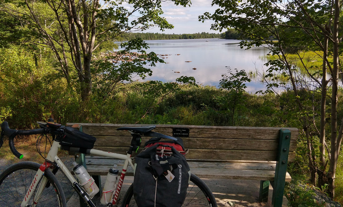 Approaching Halifax, Nova Scotia on well surfaced, pea gravel, rail-to-trail, 31 August 2018. 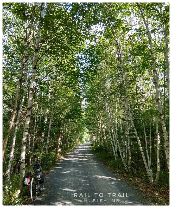 Approaching Halifax, Nova Scotia on well surfaced, pea gravel, rail-to-trail, 31 August 2018. 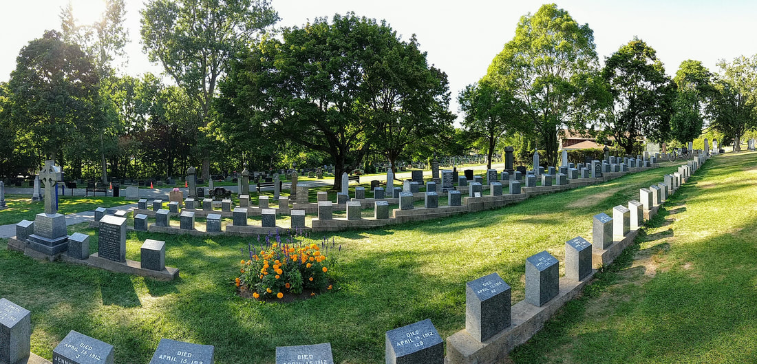 Fairview Lawn Cemetery, lines of graves where the remains of no fewer than 100 Titanic victims were laid to rest, Halifax, Nova Scotia, 31 August 2018. 3/7/2020 08:12:54 am
You really love exploring, don't you? I know that you have been to different places and I am so happy that you have been sharing all of these to us. The story that you had was nothing but inspirational. It inspires me because I love traveling. It makes me want to do more about my life and just go out and explore the world. Well, everything is possible as long as you want it to happen. Perhaps, you just have to make an effort for it! Comments are closed.
|
�
André BretonAdventure Guide, Mentor, Lifestyle Coach, Consultant, Endurance Athlete Categories
All
Archives
March 2021
|
 RSS Feed
Quick Links |
© COPYRIGHT 2021. ALL RIGHTS RESERVED.
|