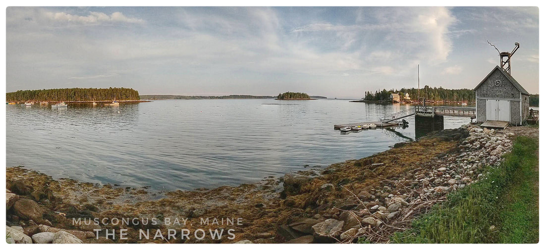
 The dock (right) at the end of Keene Neck Road overlooking Hog Island, the narrows, and other points nearby in Muscongus Bay, an enviable location to begin, as I did on 20 August 2018, a long bike tour! 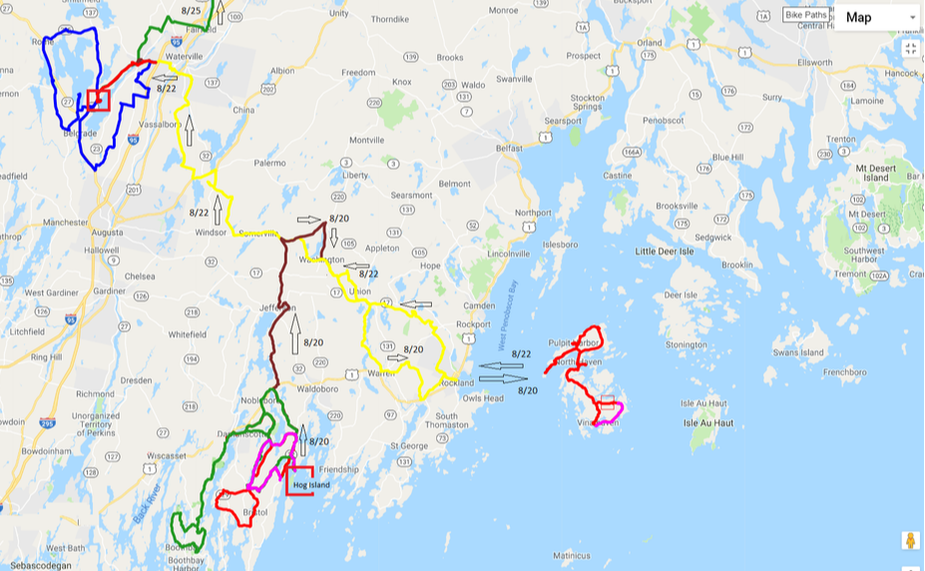 Mid-coast Maine, from Boothbay Harbor to Mount Desert Island, the foundation of Acadia National Park. Colored lines are GPS tracks from my autumn, 2018, tour including exploratory rides on and off the Pemaquid Peninsula, around the Belgrade Lakes, and on "two havens" (see text for details) in Penobscot Bay. Arrows provide direction of travel and dates the day that I completed each section. Background: This blog entry is the first of several parts, currently being written, that follow a prologue to my autumn 2018 bicycle tour. In the prologue, I provide important background info for this entry and subsequent entries. Scroll down to read the prologue which I coined Going Full Tilt to Newfoundland and Labrador. 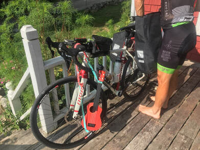 Favorable conditions for my 20 August 2018 departure from the Nash House, Bremen Township, Maine. Favorable conditions for my 20 August 2018 departure from the Nash House, Bremen Township, Maine. From the enviable vantage of the Nash House at the end of Keene Neck Road, I sipped coffee, absorbed sunshine on the front deck overlooking the narrows, and contemplated my commitment. It was the morning of August 20th, 2018, departure day from Bremen township on the Pemaquid Peninsula, part of the middle-coastal region of Maine. What lay ahead I could not say with certainty but my experience on previous adventures suggested that there would be much to overcome over many weeks of touring by bicycle through the United States and Canada including remote areas that, despite their distance from the Arctic Circle, were Arctic in reputation and character. That reputation was of particular significance to a guy riding a bicycle, wearing ... ... Lycra, and carrying limited wet and cold weather gear. And worse, I anticipated that I would approach, through the sub-Arctic extremes of Newfoundland, and arrive to Labrador, when the Northern Hemisphere was well into its transition from autumn into winter. My ambition for this tour, like all of my tours that preceded it by boot, boat, motorcycle, and much later, by bicycle, would be "a search for serendipity", a string of words that I scribbled down in one of my travel journals years ago, inside a one-man Moss tent, somewhere, after dark, in North America. Not far away from my ground pad my old friend and sole travel companion in those days, a 1982, Honda, CX 500, leaned silently on her kickstand slowly cooling-off from a day of adventure. In my twenties and thirties, Ms. Culpeper and I explored all of the lower forty-eight states and provinces east of Manitoba, over 80,000 miles, before her abrupt retirement following a collision in Quebec when I was in graduate school. Years before that crash, when I was twenty-five years old (November 1996), hands frozen, body wet to the core and approaching hypothermia or beyond, that motorcycle somehow carried me safely to a motel in Culpeper, Virginia. I nicknamed the machine Ms. Culpeper sometime that evening, or the next day, to remember my good fortune and to express my gratitude to the motorcycle, by then a trusted friend, that made that outcome possible. On this tour, as in the past, I would allow each day to unfold with as little input from me, the controller, as possible. With few exceptions, I'd avoid the highlights, those paths and destinations most trodden. Under these circumstances, some might argue, and have, that my path would take me mostly to nowhere, But experience has shown me, including evenings spent alone in many National Forests (after riding Ms. Culpeper as if she was a dirt bike, off trail, bushwhacking, standing on the pegs to get well off the road), that the path less trodden takes a curious adventurer to everywhere worth going in a short lifetime. Perhaps, in my defense and to my credit, I'm going to where the quantum beckons, with a sound that we cannot hear but our unconscious mind can feel, generated by the symphony orchestra of the Cosmos. I'm going to places and people that in their own way share my values and have something to add to my short story here on Planet Earth. An insight, large or small, a lesson to process even if I didn't understand or even notice right away. The how or why questions, like the highlights and the road most trodden, don't matter. What matters is being in harmony with yourself, our neighbors, large or small, respecting and nurturing the resonance of our probable home, the only one we'll ever have, Planet Earth. I want to descend back down now, from a view high above the Milky Way Galaxy, to its proximate, to you and I, Orion-Cygnus Arm, to an average star with it's eight or nine Planets, to a porch, a bike, and a bike rider. Momentarily, I would depart friends, Sue and Paula, in the company of my Niner Bikes RLT 9 Steel, By this point in its life, a bike ridden, mostly on long bike tours and without complaint, for close to 7000 miles. Thanks to Sue, known primarily as "Schubel" among her friends, it appeared that I'd be departing, much to my surprise, with a ukulele strapped to my Blackburn Outpost Rear Rack. Or so she wished anyway, no doubt in cahoots, an alliance or partnership, with her local community, farther out on the Pemaquid Peninsula in Bristol, Maine, of forest pixies. Out of respect for her, the pixies and their good intentions, I cooperated whilst packing my bike, barefoot, under partly clear skies, by hanging the instrument from my handlebar until the moment of departure when I deviously slipped the merry maker safely into the Nash House. In the days before my departure, I'd explored, by bicycle, primarily the Pemaquid Peninsula, west of Muscongus Bay, on which the town of Bremen was incorporated in 1828, the same year President J. Quincy Adams defeated Andrew Jackson for the second time in four years. Most of the colored GPS tracks shown on the map, above, west of Hog Island (look for a bold red rectangle) record this prologue. Viewed from a hot air balloon, the Maine coastline appears jagged, toothy, due to many, parallel, peninsulas, including the Pemaquid Peninsula on which Bremen rests. Appropriately, translated from the original Abenaki language, Pemaquid means "situated far out". All of Maine's peninsulas jut southward many miles into the Gulf of Maine thanks to the glaciers, now vanished, that shaped them. On either side of each peninsula, deep bays, such as Muscongus Bay, offer their own, unique, mini-universe of islands, some of which are forested, others are blanketed by flowering asters and other perennials, some islands are bare stone, no soil or vegetation cover whatsoever because they are washed-over each winter by storms. The bays and islands between Maine's much visited peninsulas have become a haven for curious travelers, a place to get away from the pace of a democracy, including paddlers following the Maine Island Trail. Despite their absence today, glaciers were recently in Maine, all of Maine in fact, and they played a pivotal role in the formation of Maine's jagged coastline. The ice that was present on what is today Maine's coastline was in the form of finger-like extensions, connected upstream, part of the leading edge of a gargantuan continental glacier that originated and flowed ca. south from Canada. So massive that the ice measured over a mile deep, a mile thick, in some places in New England including the Maine coast. That's a lot of weight, water being lighter than lead of course but certainly heavy, in the strict sense of the word, as anyone can recall that's tried to carry any quantity even a short distance. All that water, in it's icy state, actually depressed the Maine coastline, a part of the Earth's crust, hundreds of feet down into the mantle from which it has, ever since the ice retreated about 10,000 years ago, been rebounding. As this implies, the Maine coast rises a tiny fraction each year, imperceptible to all but the most sensitive of mankind's instruments. These factors, recent ice and rebound, have kept the Maine coastline in a rocky, you might say "young", state. There hasn't been time to wear down the granite and metamorphic, primarily, bedrock into softer impressions, such as the sandy coastline of North Carolina. The effect of Maine's rugged, rocky, coastline on the eyes is remarkable, memorable, and the source, no doubt, of many inspired relations from one human to the next following a trip to Maine's bays, peninsulas, and islands. Maine's bedrock, underlying, e.g., it's ca. 5000 islands, is ancient. Not as old as the Canadian Shield, aka the Laurentian Plateau, portions of which date back to 4.2 billion years before the present, but still ancient by any reasonable assessment, the oldest dating to roughly 647 million years: a pegmatite (type of granite) near the island of Islesboro in Penobscot Bay that, interestingly for the geologically inclined, cuts through an older (rock) formation that has not been dated. To appreciate these dates, it's helpful to recall the current scientific consensus for the age of the Earth, roughly 4.5 billion or 4,500 million years. So Maine's coastline dates back about one-sixth into Earth's history. And the Canadian Shield, from which the Laurentide Ice Sheet (continental glacier) originated and eventually flowed, it's fingers and mass, into Maine then retreated about 10,000 years ago, includes granite formations that solidified when Planet Earth was in its infancy. At the top of my tour, on the road-less coastline (accessible only by boat or bush plane) of the north shore of the Gulf of St. Lawrence, if I arrived, I would have the chance to view some of the Canadian Shield from the rails of a cargo ship and up close, by foot, especially when we were in port at Harrington Harbour. Before returning to my story, I would be deeply saddened, from guilt as thick and sticky as wet soils containing the mineral betonite, if I didn't say something about suspect or exotic terranes, the description given by geologists to rock formations that, despite their connection to a continent today, such as North America, originated elsewhere such as a nearshore island or volcanic arc caught, quite smashed actually, between two colliding landmasses. Recall the concept of plate tectonics originally proposed by Alfred Wegener. This was the case, the presence of probably both types of arcs, with implications for Maine's bedrock foundation, when North America and Africa formed a union, part of the coming together of the supercontinent Pangaea about 335 million years ago, not long after "the fishes" had their naughty heyday. One of those formations, now known as Avalonia, a former island arc, smashed and simultaneously intruded by molten rock from the Earth's mantle, then sutured to North America, would become part of Maine's present day coastline. In the midst of Avalonia, I made my way to one more view of the narrows from the dock overlooking Hog Island for a photo opp then turned back, past the Nash House, and on to the junction of Keene Neck Road with Maine's Route 32 (Waldoboro Road). I made a right turn, pedaled for about fifteen minutes, then wisely took a left onto a much more civilized, country lane, Nobleboro Road, free of yahoos and their high-speed experiments. I was on my way under favorable skies and grinning with all the anticipation of a curious traveler, the same grin that initially surfaced when I was in my twenties, exploring from the backside of Ms. Culpeper, a motorcycle that, thanks to my mother, I acquired for just 250$. Over my left shoulder, between the trees, I occasionally caught a glimpse of Pemaquid Lake. I had been a camper on the shores of that lake in my youth. The cunning and playful universe must have taken great pleasure in bringing me so close to a place that in my adult life would come to mean so much. Beyond the lake, I maneuvered a chicane and then crossed Maine's most trodden highway, Route 1. Soon I was in the company of Damariscotta Lake which I rode along for a few miles into the town of Jefferson, established in 1807 during its namesake's presidency, before turning north towards the Washington General Store. I was ahead of schedule for lunch at the store, and so I took the scenic, indirect, route, past Jones Corner, Sandhill Corner, through Hibbert's Corner, over the top of Washington Pond, and then south to Washington and its General Store which was recently transformed from a degrading 1930s-era lumber barn by the owner, a friend that I shared an internship whilst both in our youth on Matinicus Rock. Maine is the most forested state in the union, and all of that despite its long history with logging going back to kings that desired the states once prolific, massive, tall, and straight, white pine for their ship's masts. Thanks to that long history and the subsequent ecological shift in tree species prominence in Maine, the former dominance of the white pine never, so far anyway, recovered. Above the shorelines of Pemaquid and Damariscotta Lakes the forests, beautiful in color, energized by bird song, peppered with rounded stone, some arranged in walls built by settlers, from a glacial past, including massive glacial erratics, drew my gaze and filled my eyes with nature's wonderful geometry. Among the easily recognizable trees, at bike speed, were the hardwoods, maple and birch, and a softwood that is much more dominant on Maine's forested islands and adjacent coastline, the red spruce. Soft, in appearance and reality, mats formed by mosses, their glowing green vitality a product of a pigment, chlorophyll, and reflected light, formed inviting beds above the moist soils below the trees. Here and there, a variety of delicate lichens, in shades of green, pink, and gold, held tight to bark and stone. Eyes closed, to focus for a moment, on the soundscape above the lakes, I could easily identify amidst the symphony of bird song the striking red-eyed vireo, the patient eastern phoebe, and the (sounds like) "teacher, teacher, teacher" of the ground-sleuthing ovenbird. Larger forms also made themselves noticed, here and there, including a group of wild turkeys and numerous white-tailed deer, sadly, to no fault of their own, the harbingers of a tick and the dreaded Lyme's disease. To arrive to Matinicus Rock, under any circumstance, is a rare event no matter what the comparison. But just as certain as the statement 'life exists elsewhere in the universe' given the numbers, a minimum of 200 billion observable galaxies each with ca. 100 billion stars and many of those, as we now know, orbited by planets, it is also certain that a few fortunate hominids would arrive to this outpost at the edge of Penobscot Bay. Two among them, Sean Donaghy and I, arrived as Project Puffin interns in the spring of 1995, naive and full of wanderlust, to this isolated island oasis composed of mostly granite with some prominent, grey in color, basaltic intrusions (dykes) surrounded by water contaminated by salt, other minerals, millions of life forms, and sadly a lot of mankind's trash. Trash aside, the oasis, its setting and historical significance as a light station, inspires even the most introverted minds, which described neither Sean, owner of the Washington General Store, nor the author of this circuitous blog entry. By the time I reached the intersection of Razorville and Old Union Roads in Washington, Maine, an area first settled by Euro-immigrants, the Nelson's, in 1797, I was well into the full expression of a smile born from reflection of many shared and cherished, youthful, memories. Sean isn't a short fella by any means, somewhere between above average and basketball. He's always kept a beard or a minimum of scruff, at least from the images and impression that I've otherwise collected over the years. Picture a lumberjack, fitting given his history with competitive axe throwing, a carpenter, father, and friend to strangers, vagrants, vagabonds, etc. When he gives you a hug, ask him to "bring it in" and he'll oblige I assure you, it'll reach under your rib cage. When he speaks, or sings, his voice has a deep resonance. That too will touch your soul. He seems to prefer bright colors, plaid patterns. And plaid aside or withstanding, no doubt Carhartt is a theme, on his hooks and in his dresser, preferably bought used or otherwise in Maine's eclectic shops, from the famous LL Bean Store in Freeport to the 2nd To None Thrift Shop in Ellsworth. Sean was busy enough the day I arrived, and most days no doubt, nurturing with his family the store that they invented a few years ago, that I was able to settle-in to my second favorite thing, after cycling, eating (!) before we had a chance to embrace in bear-like fashion. Lunch was served-up by his kitchen staff, pizza then a sandwich then perhaps a bit more, can't recall for sure. And I eventually departed with more yummy snacks, bought from his shop, in my Blackburn rear panniers. We found harmony over coffee, enough to satisfy someone traveling by boot or vehicle vs. a cyclist, the latter being famous for their predilection for the dark brew. It was as if we had never departed, years ago, from a shared experience on Matinicus Rock. It's always this way with friends, as it should be with strangers too, color, beliefs, and other superficial etceteras withstanding. For my part in this brief adventure we often refer to as "life", I try to do my best to live as if strangers were friends in waiting, at a country store or otherwise, for a reunion that will give back more than any purchased object ever will. Favorable skies, blue with spectacular, an odd one here and there, puffy clouds, concerned me not one iota as I said my goodbyes to Sean and his family, including their youngsters between bites of a childhood favorite among Americans, no exception noted, pizza. I backtracked a few yards, meters, fathoms, whichever you prefer, to Old Union Road and turned right towards the Maine State Ferry Service that would carry me to my destination on the first day of the tour, the home of Mr. Goodhue. I did my best to remain on the road-less-traveled, which took me past Union and its namesake fair, past Round, Seven Tree, and Crawford Ponds, past Quiggle Creek, and around the south side of Spruce Mountain before dropping due south a few miles to a backdoor entrance, a fun, fast decent into the picturesque and historic coastal town of Rockland, Maine. I'd been here many times before, the coastal going and coming location for all of my trips to Seal Island and Matinicus Rock as a supervisor and intern for Project Puffin. In fact, it wouldn't be a stretch to say that the place was, to me, familiar as home, which made my approach from the northwest on Talbot Avenue even better. I had never been through the Talbot gate, the impression of the new in advance of an impression of the familiar was as delicious as locally baked strawberry-rhubarb pie after a lobster roll made the same way. The Rockland ferry provides daily service to Vinalhaven and (fewer trips) North Haven, two island communities celebrated by tourists and locals. The islands are about centrally located in Penobscot Bay and are favorite destinations among pleasure boaters. Both islands have been havens for fisherman for some time, to nearly the beginning of Euro time in the New World. Today's fleet focuses mainly on lobster fishing during months when the lobsters are near shore and the weather is favorable (summer); exceptions are a few hardy souls that follow lobster far out to sea, beyond Seal Island and Matinicus Rock, to their deep-water winter residence. Between the port in Rockland and the ferry terminal on either island is a wide open expanse of salt water. A no-man's-land where birds, including a variety of gulls, shags, and alcids, go about their daily priorities with few distractions. Critters, large and small, below the surface do the same including crowd pleasing harbor porpoise, minke whale, grey and harbor seals, all resident (non-migratory) species in the Gulf of Maine. A lucky passer-by might also get a glimpse of a right or humpback whale when these species visit the area. Encounters with Planet Earth's biodiversity aside, I first became aware of the peaceful, relaxing, pleasure provided by ferry crossings, even the short pulls, by chain, across river channels when I was touring North America on Ms. Culpeper. For example, I still have fond memories, crisp, of crossing the Mississippi (east to west) on a small car ferry from Moduc, Illinois to Sainte Genevieve, Missouri. Not long after exiting the ramp on the Missouri side, I rolled into the small community of Sainte Genevieve, and not long after that into the Ozark's, a thickly forested, mountainous wonderland that I was excited to visit for the first time. Contrast this with a trip that might begin with an ascent of a massive steel and concrete bridge over the Mississippi, past the famous arch in St. Louis where I've been told local gangs enjoy spraying bullets from their uzis into the river, followed by a lengthy drive through an urban jungle, before exiting into that more desirable space, the Ozark Mountains. Although there would be no sweet gum blossoms and singing Kentucky and cerulean warblers above sheltered creek beds, the satisfaction of traveling by boat to Vinalhaven, a moment to reflect, to be grateful, delivered all of the satisfaction of my previous ferry crossings. Once the ferry departed Rockland, I found a place where I could observe the World through my, quite dated and beat-up, Bausch and Lomb Elite binoculars and settled-in to a rest from pedaling. The island of Vinalhaven is an unusual space, quite connected, often open among its residence to a degree not typically found elsewhere in the United States where deception of fear is too often a primary motivator. Years ago, when I was a supervisor on Seal Island on a return trip to the mainland, I began driving away in a car that I thought was my friends only to discover, picture a man running up alongside me, that I had absconded with the wrong vehicle. Such is the risk islanders take when they leave their keys in or close to the ignition, such as the ash tray, as they often do on the island. By the way, he was not offended at all, he just wondered who I was. After a moment, we had the whole thing clarified and I was on my way, in the correct car the second time around, to shuttle gear from a boat operated by John Drury, a legend equivalent to the great naturalists of previous centuries, to the soon-to-depart ferry to Rockland. Mr. Goodhue, aka, Terry Goodhue, my host for the next two days, met me at the dock, a kind gesture. And then, equally kind, patiently waited for the cycling addict to ride to his place, about five miles away, as he followed me in his "island" car. Terry is a master of all mediums, an extra-ordinary artist, he is a humanitarian and an educator, a lover of all warm hearts and living phloem, he is all things that humanity celebrates: his friends and any curious stranger that reaches out to him among them. And because of his exceptional ability to nourish any one, or thing, in his care, including a juvenile kestrel that he taught to catch mice in his bathtub, his home, the second that he's now built using hand tools and post and beam construction off of Poor Farm Road, when viewed from the plastic duck pool, adjacent to the driveway, is partially occluded by gardens that spill-over a rough, leaning this way and that way, pieced-together fence built to keep-out the deer. His peach trees, equally vivacious, which he planted a few years before construction of his second home, foresight withstanding, produce more fruit than a man can eat, a fact that I suspect his neighbors have never complained about. Just outside the fence, when I arrived, a coterie of quacking ducks, fattened on grain, food scraps, and local bugs, patrolled the spaces between the garden, Terry's modest home, and the area reserved for coming and going, where his aged automobile rests most of the time. The following morning, fattened on peaches and Terry's exceptional cooking, I took some time, many hours, to explore beyond Poor Farm Road by bicycle. Places that, despite my long tenure in the area, were outside of my experiential universe. A right onto dirt-surfaced Poor Farm Road led me to asphalt, first Round Island Road, a right turn, then right again onto North Haven Road, a cul-de-sac that leads to a dock where, for a few dollars, foot and bicycle traffic can hail a water taxi to North Haven which is by now in full view just across the Fox Island Thoroughfare. At this juncture, charm is everywhere, it is pure Maine, a beautiful menagerie of fishing boats floating peacefully below structures elevated above the water on pilings, sheathed by natural wood or typically stained red, and homes, often white washed and fenced in Victorian-style, rising above the waterfront, built one above the other and in rows following the natural contours of the island. Per Terry's instructions, I hailed the water taxi using the juxtaposed phone that is attached to a pole not far from the aforementioned dock. Soon thereafter I was wiping tears as the wind from the boat speed, casual but enough to get my eyes watering nonetheless, found its way into my eyes but only for a minute or two, the time to cross the thoroughfare. On the opposite shore I thanked my captain and then eagerly departed onto the hard and dry bits of a "life island" as my friend Schubel would call it, an island that up until this moment I had not visited. Navigation is not a significant challenge on a relatively small island surrounded by the sea. I passed through a quaint village, the village of North Haven, then turned north before making a left onto Crabtree Point Road. Eventually the road turned to dirt, after about eight or ten lovely miles up and down gentle hills, past hay fields and vacation homes, all the while the activities of coastal living in view beyond the terrestrial. Crabtree requires an about-face, another cul-de-sac, I obliged and following a brief chat with a young woman that warmed my heart, I was on my way, with confidence, towards Pulpit Harbor. I visited the latter, a charming village, briefly before continuing my bicycle tour on North Haven. I approached Salt Point on North Shore Road with intentions to visit that part of the island but a near flat changed my itinerary. Instead, I stayed on North Shore then South Shore, well above the waterline, all the way back to Main Street and the water taxi service that would, for a few dollars, take me back to Vinalhaven. My exploration of North Haven was a great success, no matter how insignificant among conversations of popular tourist destinations, stunning weather heaped on fond memories that to fully appreciate you must explore by bike, foot, or paddle. The natural sounds, smells, and other feelings that our minds translate for our consciousness are at their very best, mature you might say, when taken in their raw form - that is, fully in the face, minus a windshield and the dreadful noises and pollutants produced by our fossil fuel-propelled machinery. These machines have their place in life, hopefully a lot less moving forward, but that place lay far away from experiences that will nourish our souls. Two evenings with Mr. Goodhue, a friend that I met whilst in the company of a migrant bobolink on Matinicus Rock (May 1995), was nowhere near enough to satisfy my craving to spend time with one of my beloved mentors. We talked into the night, but not much past ten post-meridian I suspect, both of us being quite susceptible to a pumpkin transformation after about nine if our minds are not already producing the spindles of deep sleep. Terry managed to convince me to rest my legs and ride with him the following morning back to the ferry terminal. By late morning, I was climbing Talbot Avenue, at a pace much slower than my exhilarating descent into Rockland a few days before. But the pace suited me on this particular morning, I reflected and smiled to the top of the hill overlooking Rockland Harbor, a glorious view any time of year, as I thought about the last two days and looked forward to the next visit on my itinerary, two nights that transformed into three, unexpectedly, in the company of a good friend, adjacent to Messalonskee Lake, in the Belgrade Lakes Region of central Maine. Gravel roads are encouraged on my bicycling tours, they are always scenic, secluded, obviously an inspiration for the traveler in search of serendipity. In the vertically-oriented image below, you'll find a digitally-captured (Android MotoX4) moment from a gravel rendezvous that I navigated not long after departing the Rockland ferry. Rain was heavy at times as I made my way to Belgrade via the Washington General Store, one more opportunity to sip coffee with Sean, and the Green Spot in Oakland, Maine, where the Athanus sisters were generously anticipating my arrival. My route from the General Store sampled three counties, Knox, Lincoln, and Kennebec. Some of the roads that nourished me today, in part because of the near absence of mankind's fascination with extreme noise, included Young's Hill, Patrick Town, and Windsor Neck. Along these routes, I passed by Three-mile Pond, China Lake, and Tabor Hill before crossing the mighty Kennebec River into Waterville, Maine. Not far, a few miles from the bridge and fewer from the Interstate 95 underpass on State Route 11 (Kennedy Memorial Drive), the yellow and green signature of the Green Spot came into view. The Green Spot is a haven first and foremost for the celebration of flavors, genuine French cooking and always fresh, from baguettes to a variety of warm salads to famous lobster rolls to the highest quality produce available from local, green farms; and a close second, a social opportunity that is reminiscent of the passionate and unforgiving debate of the Enlightenment, an exceptional period in our species social evolution, including ideas about government and governing, popularized by the words and reputations of famous characters, Hobbes, Lock, and Montesquieu among them. The Green Spot is a gathering ground for prophets and gypsies, an oasis for both the introvert and the extrovert, an unanticipated melting pot that's been collecting and sharing ideas and experience for over forty years, going back to a naive decision made by two college-aged sisters, Tanya and Brenda Athanus, in 1976. I first met the sisters though a mutual friend, Mr Goodhue, when Terry and I stopped for lunch during a motorcycle tour of Maine, years ago, that included Acadia National Park and the auto-road to the summit of Cadillac Mountain, a modest 1,530 foot (466 meters) summit overlooking Penobscot Bay that nonetheless claims victory to 'the highest point along the North Atlantic seaboard'. I suspect that I was initially shy in the midst of three minds to which I eventually recognized a kinship even though I wasn't ready to move much beyond observation, absorption, and reflection, the primary activities of an apprentice. But childhood shyness withstanding, I eventually developed a strong bond with Tanya, as well as a friendship that I value with Brenda. Their kindness, love, and ability to challenge my thoughts, add to them, etc, ensures my palate will be enhanced with many more visits to their store, and homes, not far away, in the town of Belgrade above Messalonskee Lake. Despite consumption of a meal, a second lunch, that was far too significant for a cyclist with about ten additional miles to pedal between the Green Spot and Tanya's guest cabin, I still managed to make my way, without gastrointestinal incident, to my next home-away-from-home. When I arrived, I literally plunged in to Messalonskee Lake, head first, to encourage the cooling effect of autumn water on the skin and to wash the salt from, in part, the pizza I annihilated earlier in the day at the Washington General Store. The forest and bird song above Messalonskee Lake, and Tanya's company, would prove easy to settle-into and subsequently, difficult to depart from; its comforts, explorations, and other privileges, its known-knowns versus the many unknown-unknowns of the road ahead. Between social mornings and evenings spent chatting with Tanya, I took advantage of being centrally located in the scenic Belgrade Lakes Region of Maine to explore, by bicycle of course. The map at the top of this blog entry includes GPS tracks that weave between the lakes from this bit of local inquiry. Other than Route 225, known locally as Rome Road (namesake nearby Rome, Maine) which was a nightmare on a bicycle, no shoulder, high speed wackos, the very worst-case scenario, I would encourage readers to plan a similar tour of the area where there is no doubt, much more to witness from the (ad)vantage of a thinly cushioned saddle than my brief sojourn provided. Brevity, by the way, had no effect on my satisfaction. Two days without panniers or other preclusions added significantly to my cycling efficiency and enjoyment. The Belgrade Lakes are connected one to the next, like a string of pearls, the last in line and the second deepest is Messalonskee Lake which gives life and water to Messalonskee Stream, a tributary of the Kennebec River. Like many of the streams and rivers in New England, Messalonskee Stream once provided water power for its small part of industrial America, specifically a woolen mill and several factories that produced axe heads, so many that nearby Oakland was once known as the "axe head capital of the world." The bed of Messalonskee Lake was excavated during the last glacial advance in North America, by the Laurentide Ice Sheet. The lake's surface was subsequently raised by the town of Oakland in 1905 with the construction of a dam above Messalonskee Stream. Above the shoreline of nearby Great Pond, I found some dirt tracks that led to stands of impressive, tall, white pines. The forest floor below was thick with needles and the smell of pitch. Elsewhere, between the lakes, the hardwoods maple and birch and their bird fauna dominated, as elsewhere on my short tour to date. I hadn't anticipated that I would feel a pause in my momentum only a few days after departing Bremen, but as I settled into a cabin that recalled my minds vision of the scene above Walden Pond, a cabin and setting that inspired unfiltered reflection, I nonetheless slipped into a comfortable, natural space for my modus operandi, a place that my mind wasn't immediately willing to give up. Underlying my minds pause was primarily one of the most unknown among the unknowns on my tour, crossing Stud Mill Road. A minimum of 60 miles, through Maine's North Woods, all on gravel roads and no doubt of varying quality. Fortunately, necessarily in my view, I'd be attempting the route on a Sunday, the only day that logging trucks are not active on the road this time of year. Otherwise, the logging roads of the North Woods are no place for a bicycle, as I learned years ago when I looked south down a dirt stretch from a remote border crossing, Canada-US, whilst traveling by motorcycle through Quebec with Mr. Goodhue. What I saw coming my way remains, even in memory, frightening to this day: one massive, high speeding, fully loaded, logging truck and several behind that were completely encased in flying dirt and dust. The road literally vanished amidst this onslaught of earth and turbulence. How the drivers behind a lead truck manage to stay on the road, at close to US highway speeds, I have no idea. Cyclists of any variety beware, these gravel roads are owned by the logging companies and they make the rules. During the second morning of my visit with Tanya, in an attempt to soften concern for my arrival to Stud Mill Road, I opened Google and started searching for anyone associated with bicycles or recreation close to the communities of Old Town and Milford, Maine, the latter on the east side of the Penobscot River where I'd enter the North Woods. That search was successful and bore lots of comforting fruit. I spoke with a fellow that lived in the area and had spent considerable time exploring Stud Mill on a gravel bike. In fact, a group of his buddies were intending to ride half the road, half-way to the Canadian border, the same day that I would be on the route. Without making a note of his name and I've since forgotten the name of the shop as well, sadly because I'd love to share their website, I hung-up the phone and immediately felt better. In the meantime, I had extended my stay, above Messalonskee Lake, from two to three nights. Departure day for the locally owned 'Milford Motel On the River' was set for 25 August. The next morning, 26 August, the trip would get very real as I ventured forth onto Stud Mill Road. In my next blog entry, I'll recall my bicycle explorations from the Belgrade Lakes to Milford, Maine, across Stud Mill Road to Calais, a remote town in Maine that is adjacent, on the opposite bank of the St. Croix River, to Saint Stephen, New Brunswick.
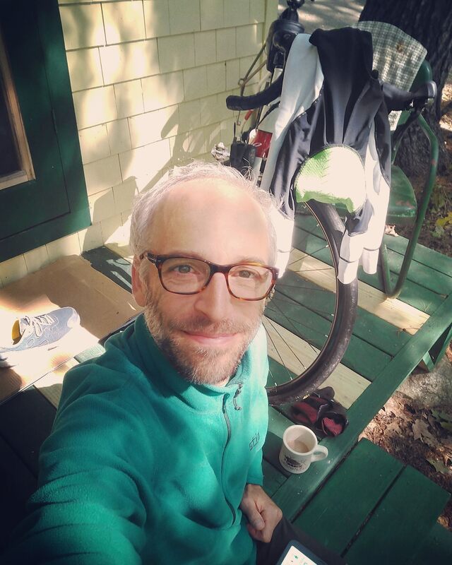
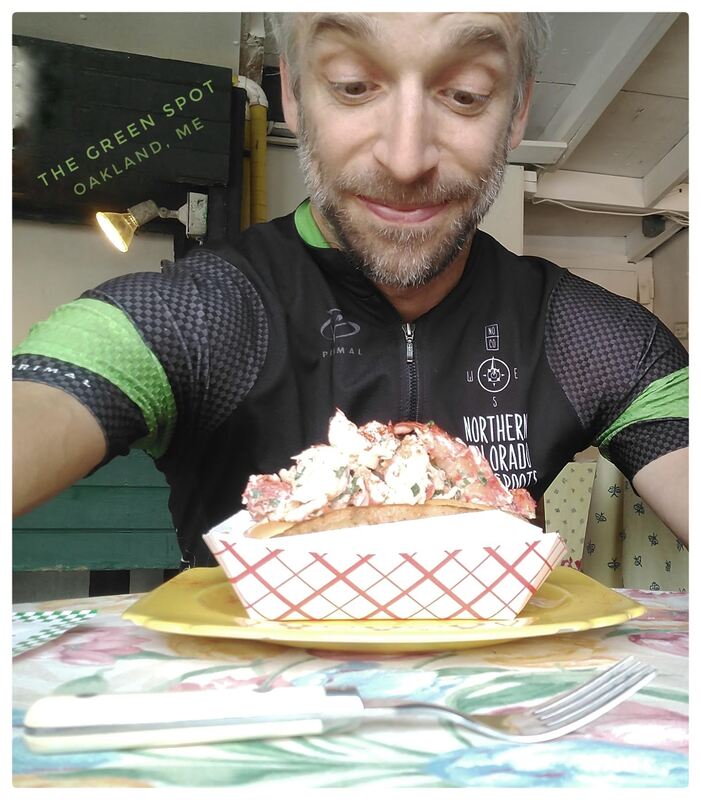
(left) Enjoying the preferred fuel of a touring cyclist, coffee, on the deck of Tanya's cabin above Messalonskee Lake, Belgrade, Maine (23 August 2018). (right) Anticipating my first bite of a lobster roll from the Green Spot, Oakland, Maine (24 August 2018). 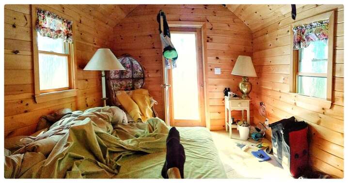 The life of a touring cyclist has its highs and lows, this was one of the highs! My feet up, glutes resting on a soft bed, a short walk to Messalonskee Lake, amidst the forests, the birds, and the pixies. A view inside of Tanya's cabin, ca. 23 August 2018. 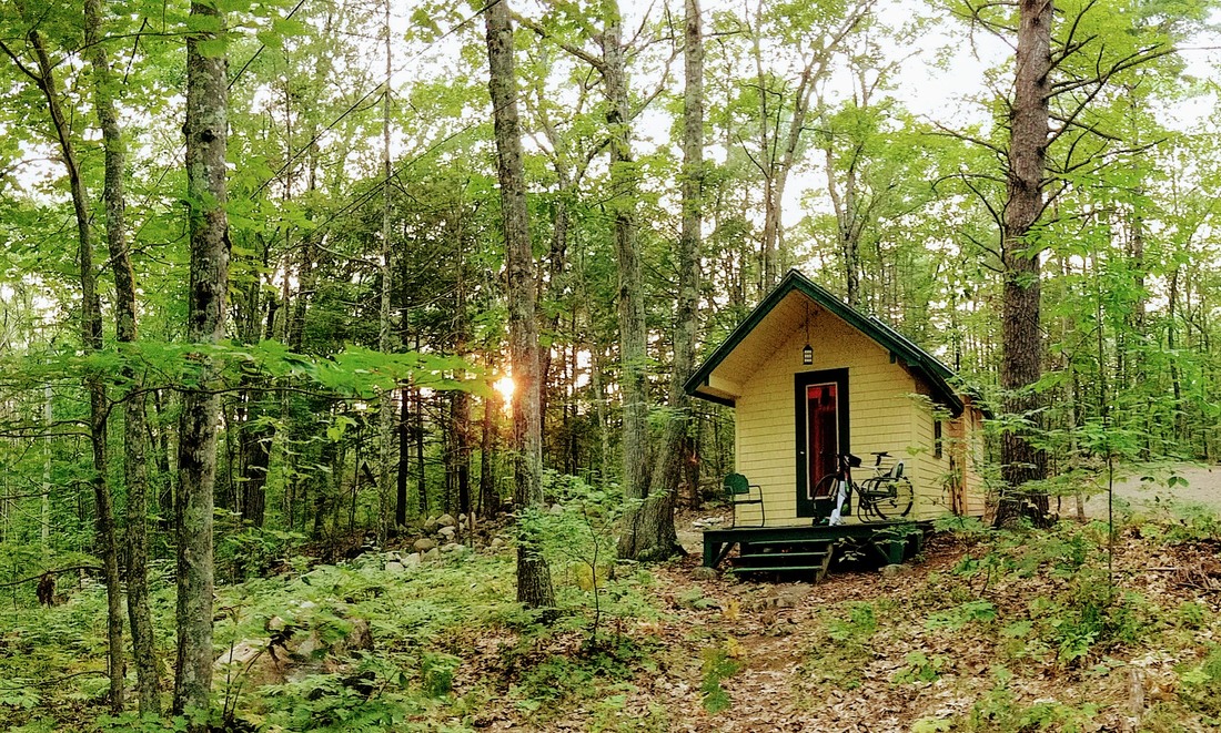 Welcome to the woods above Messalonski Lake, and Tanya's cabin, reminiscent of Henry David's in size and setting, that provided me with shelter, deep sleep, and more for four days and three nights, 22-25 August 2018. 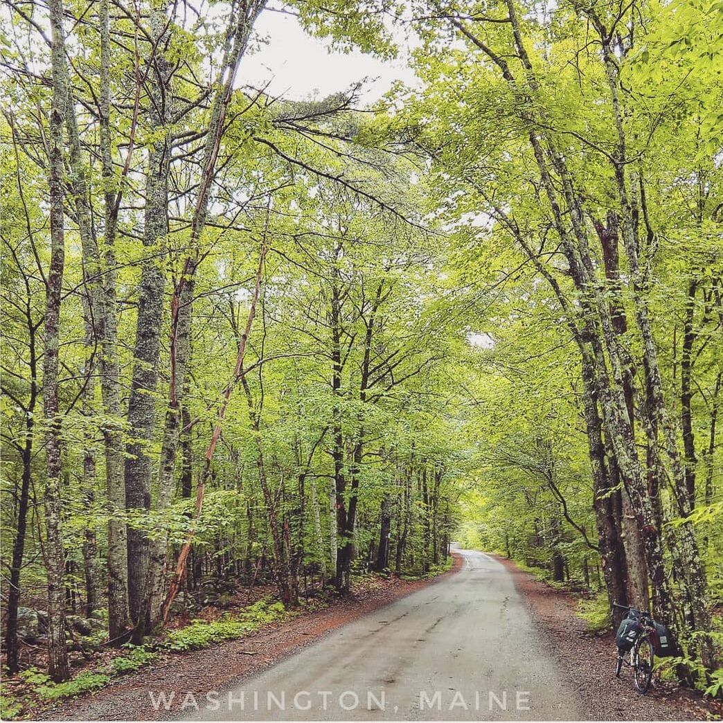 Somewhere in Washington, Maine, en route to the Washington General Store on an enviable stretch of road-less-traveled of the gravel variety, 22 August 2018. 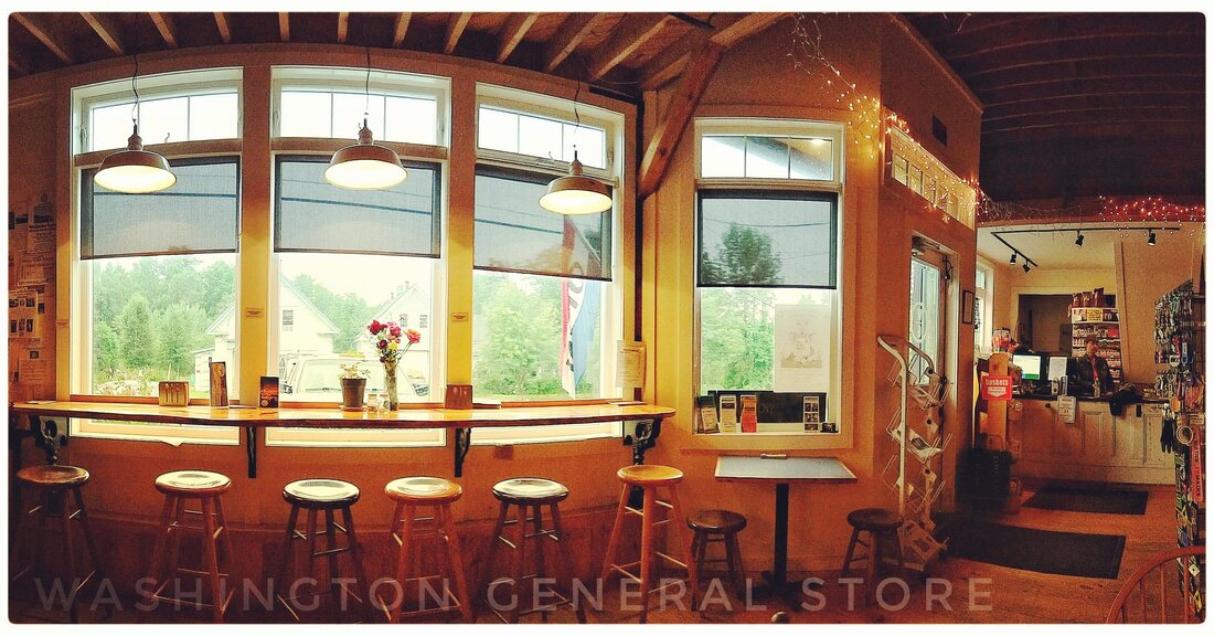 Welcome to the Washington General Store, the dream come true of Sean Donaghy and his family. My advice is go there, arrive hungry, and be selfish. Guten Appetit! 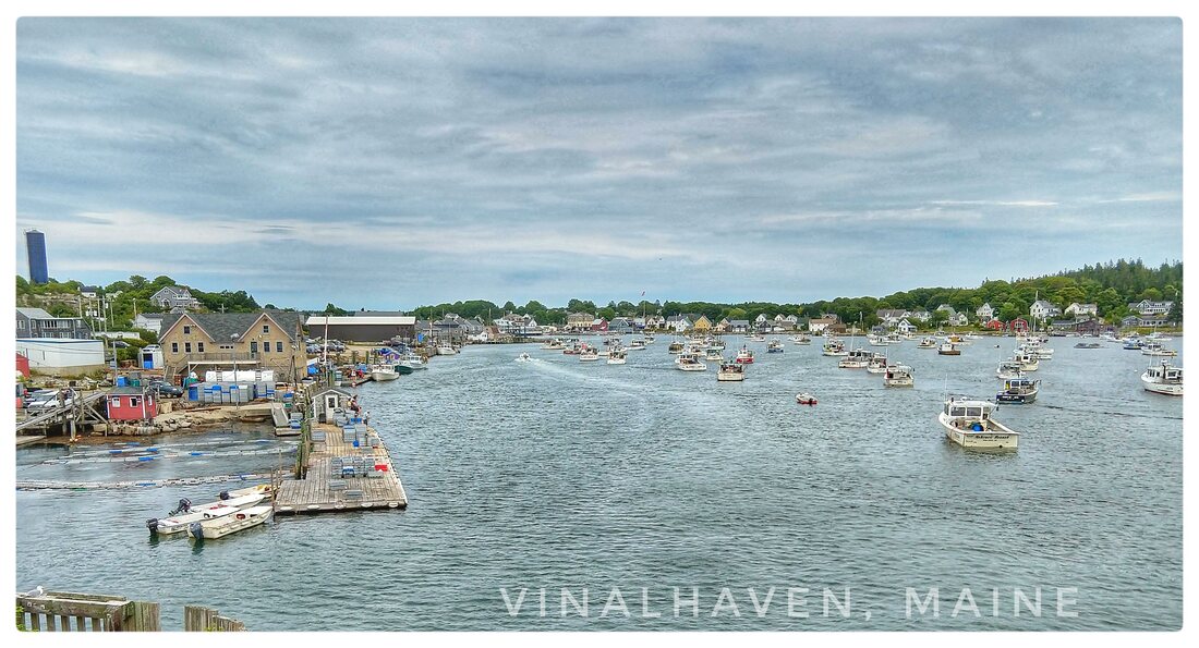 The main harbor at Vinhalhaven, from the perspective of a visitor arriving on the ferry from Rockland, Maine. (20 August 2018) 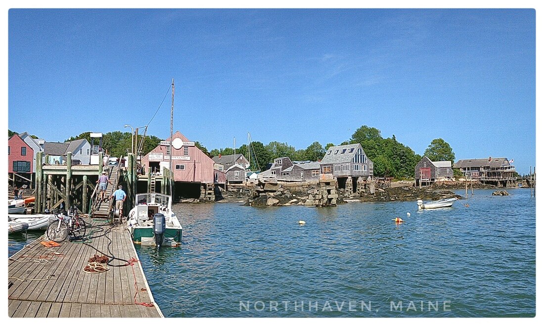 The dock on North Haven where the water taxi arrives and departs. (21 August 2018) 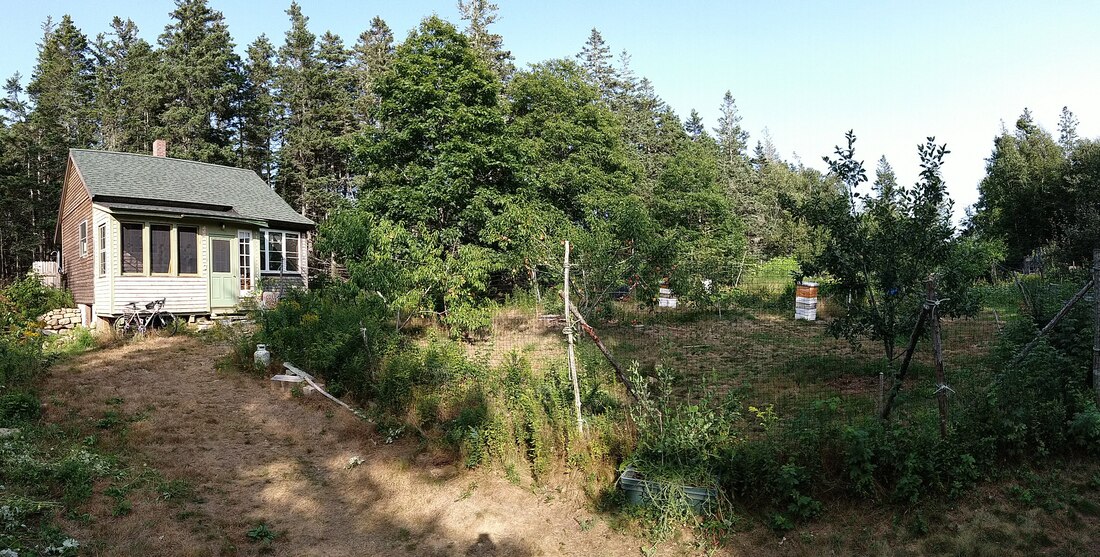 The home, gardens, and bees assembled by Mr. Goodhue, off of Poor Farm Road, Vinalhaven, an island about in the middle of Penobscot Bay, Maine. My enviable base camp from 20-22 August 2018. Comments are closed.
|
�
André BretonAdventure Guide, Mentor, Lifestyle Coach, Consultant, Endurance Athlete Categories
All
Archives
March 2021
|
 RSS Feed
Quick Links |
© COPYRIGHT 2021. ALL RIGHTS RESERVED.
|