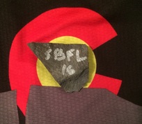
 Consistent with all of the events offered by the Colorado Endurance Series, racers competing in the Salida Big Friggin Loop (SBFL) must self-support including water, food, and navigation. There are no course markings, aid stations, or emergency personnel anywhere on the course. The SBFL comprises over 110 miles of single-track, (mostly) dirt road, and jeep trail. Most of the course lies between 8,000 and 10,000 feet (2438-3048 meters). Below I describe the course, my experiences along the way, and offer a few suggestions for anyone that might be considering taking-part in this grassroots event. 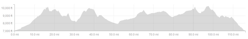 Salida Big Friggin Loop elevation profile, 11 June 2016. Image courtesy of Strava. 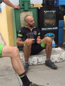 Enjoying post-race discussion at the Cafe Dawn (9 June 2016). Enjoying post-race discussion at the Cafe Dawn (9 June 2016). A race profile alone, like the one provided above, isn't enough to know just how tough a race will be. However, in the case of the Salida Big Friggin Loop (SBFL), it's enough to initiate respect from any sensible mountain biker. Starting a few hundred feet above 7,000, near the heart of downtown Salida at the Cafe Dawn (barista's take note), the race begins with an initial ascent, with few breaks to shake-out the legs, that tops-out at ca. 10,000 feet on the forested slopes of Mt. Shavano (14,235 ft [4,339 m]). Part-way up that opening climb, the race course crosses 8,000 feet above sea-level and keeps climbing. From this point, until the final descent back into Salida, across 100 miles of single track, (mainly) dirt roads, and jeep trails, the racers body will rarely drop below or above 8,000 and 10,000 feet, respectively. And a significant portion of their day will be spent breathing the thin air above 9,000 feet. From Mt Shavano, competitors roll onto the Colorado Trail as they turn north towards another giant, another "fourteener" as they're referred to in Colorado, Mt Princeton (14,204 ft [4329.3 m]). Both of these majestic mountains are part of the impressive Collegiate Peaks, a commanding geographical feature of the Arkansas Valley, a never-forgotten vista among anyone that's been lucky enough to view it. After a massive climb from Mt Princeton Hot Springs to the upper forested slopes of Mt Princeton, the race continues north on the Colorado Trail to Cottonwood Creek. Just before Cottonwood Creek the course departs the Colorado Trail and begins heading east on a graded dirt road towards downtown Buena Vista, a town known locally as BV. It was at this point, the point when I should have exited the single-track, that I made a GPS error and went off course. Before long, I was, dreadfully, well over 10-minutes into an off-course blunder. At that point, I was still on the Colorado Trail when I should, instead, have been approaching downtown BV on a fast, paved, road into town. All told, when I eventually returned to the course, I'd given-up 23 minutes and added a few miles, with climbing, to what would be a monumental day on a mountain bike. In hindsight, I remained fairly calm given the extent of my mistake, I turned around and repeated the extra section in reverse. Once I returned to the course, I tucked my body around the Jet 9 RDO top tube and sped down the road, in the correct direction, towards Buena Vista. Downtown BV is roughly 50 miles along the race course from the SBFL starting line, about the half-way point. Riders typically make a quick stop in BV to resupply, especially water. Consistent with the rules of the Colorado Endurance Series, the SBFL rule book states that riders are required to self-support, that includes water, food, and navigation. The course is completely unmarked. Other than local competitors that know the course in its entirety, the remainder of the racers rely on a GPS such as my Garmin eTrex 20. In 2016, organizers diverged slightly from their hard-and-fast no support rule when they accepted Boneshaker Cycles request to offer neutral support, a place to fill your water bottles, etc, to SBFL competitors. Unfortunately, I rolled-past the shop, didn't see it, as I came into the downtown strip. Alternatively, I ran into a small restaurant at the east end of town and the wait staff were happy to fill my bottles. From BV to Salida water options are limited to residential homes, campsites, and natural water sources such as ponds and creeks. It's absolutely essential to fill up in BV! The day before I drove about 15 miles south of Trout Creek Pass along the course and stashed most of a gallon of water, that stash was my last water stop for the day. In total, I drank 9x26 ounces; two bottles on the bike, a third bottle in my middle kit pocket. A easily could have drank a tenth bottle if one had been available in the last 20 miles of the race, but the nine were sufficient. Just east of downtown BV racers ride over the Arkansas River on a narrow foot / bicycle bridge and take a right onto the Midland Trail. Immediately, the trail begins to pitch up, a familiar experience by this point on the course, and the next massive climb, of many, in the big friggin loop is underway. Riders continue for many miles on the Midland Trail into the Four-mile Recreation Area before transitioning to dirt road for the remainder of the ascent to Trout Creek Pass on Highway 285. Well before reaching Trout Creek Pass, the race course has entered South Park, a high elevation, prairie-complex surrounded by impressive Rocky Mountain vistas. At Trout Creek Pass, the route turns towards the south, towards Salida. No doubt, among SBFL rookies, I wasn't alone when I celebrated, quietly, a little, in my mind when I reached this point. I'd regret that celebration 10, 20 miles farther along. Although a lot has been accomplished by the time a rider reaches Trout Creek Pass, so much lies ahead that they would be best served by holding-off any celebration, no matter how small, to avoid disappointment. In hindsight, I should have held-off my small victory grin until at least Futurity Ghost Town. At Futurity, racers have the option to hop-off their bike and search for a Futurity Chip, the closest thing to a trophy they'll garner from the Salida Big Friggin Loop. In 2016, fifteen chips were prepared, all composed of flat, grey shale, of various sizes, with the letters 'SBFL' hand-painted, not so neatly, on their surfaces. Historically, the chip's value has been a 30-minute time-deduction off your finish time and 2016 was no exception. Futurity is about 90 miles into a roughly 110 mile 'long friggin loop' back into Salida ... that's 20 miles ahead in addition to 90 behind. If you decide to line-up for the SBFL some day, don't be misled (you're not done climbing) by the significant descent out of the ghost town of Futurity. After locating the chip stash and adding one of the smallest ones to my kit pockets, I descended between aspen groves on a fast, fun, two-track. At the bottom, the forest service road ended and another offered a left or a right option. The race continued to the left before a right at the next split, the beginning of another seemingly massive and steep, by this point in the race, climb. The climb is apparent as soon the left-hand turn is made, and that's enough to cause significant disappointment despite the beauty of the surrounding valley. And there is much more ahead, after that initial climb many, many, smaller climbs follow. Eventually, from the bottom of the descent from Futurity, I spun my way into an area called Aspen Ridge. As I continued to ascend, descend, and ascend, over-and -over again into and within Aspen Ridge, I suffered as much as I had in any race before. Each patch of shade beckoned me to stop for a visit, to give up. But if you're willing to start this race chances are you're stubborn enough to finish. Fortunately, for my long-term happiness, I turned out to be a stubborn participant for which I was eventually rewarded with a descent down a full-on (wide and graded) dirt road, known as the Ute Trail, to the trailhead of the recently completed Cottonwood Trail. Cottonwood, like Futurity, was another opportunity to grab a time-deduction. Riders received a 100 minute time-deduction, off their finish times, for dropping Cottonwood. I certainly considered bypassing Cottonwood and heading down the Ute Trail to town. By-way-of the Ute Trail, I would have been inside of downtown Salida within about 15 minutes. Instead, I took a left, adjusted my suspension to 'trail mode', and began what would be a fun descent down a well-built, designed-for-mountain-bikes, roughly 12-mile section of single-track. Because of this experience, the next week, after the race, I rode-up the Ute Trail twice to drop Cottonwood just for fun. The carefully routed trail includes a variety of challenges including dry gorges with technical drops and banked single-track through Ponderosa Pine forest, this trail shouldn't be missed if you're a mountain biker visiting the Arkansas Valley. The thinking was, I suspect, when the 100 minute time-deduction was chosen, that Cottonwood would be a continuation of the suffering that riders could otherwise escape by descending the Ute Trail. But what I discovered, soon after rolling off the dirt road and onto the single-track, was the trail experience, a fast, flowy, fun descent, actually revived my ambition to be a part of the race. Within moments, I was smiling as I guided my Jet 9 RDO from Niner Bikes smoothly down the trail. From the bottom of Cottonwood, on the south-side of Salida Mountain (aka, "S" mountain) competitors were told they could take any route they desired back to town. I continued straight from Cottonwood, farther along the Cottonwood Creek drainage before climbing back into Pinon-Juniper forest, and eventually exited the Salida Hills on the Mesa Trail. After spending so many hours alone, I'd been alone since Cottonwood Creek west of BV, it's a strange experience coming back into the hustle and bustle of human society, even into a small town like Salida. When I noticed a rider coming into my view from the left, I was trying to reconcile my new environment with the one, a moment ago, I had left behind. From reconciliation my minds focus very slowly shifted to the rider that seemed familiar and they were. Here was the rider that was behind me, out of view, when I'd continued straight on the Colorado Trail west of BV instead of turning right onto a dirt road. For the last six hours I'd been alone, but now I was looking at the last rider that had been close to me on the course. What I didn't know was he was presently in second place. Of course, I did know that he hadn't yet crossed the finish line. Ignorance aside, I knew I was going to try to pass him before the finish at Cafe Dawn. He made his way, without noticing me, towards the F Street Bridge. Over that short half-minute or so, I cut the distance to him in half. As he crossed over the bridge, I rolled-up behind him, just a few bike lengths away. In hindsight, after talking with him post-race, he was trying to revive his unresponsive GPS and so never noticed me coming, or going. At the first four-way stop sign in town, he went straight while still (mostly) looking down at his handlebars. I went right, picked up my pace, and finished with a sprint to the coffee shop. Despite a 23-minute off-course blunder and considerable mental suffering as I approached and rode through Aspen Ridge, I'd managed to catch and pass one rider in the last few tenths of a mile to finish 2nd overall. Suffering forgotten, I soon settled into celebration with my teammates, including the 1st overall finisher, Ben Parman, and all of the other Long and Short(ish) Loop finishers, among others. Before a late sign-up for the SBFL, my June race calendar was left intentionally empty. The plan in June was to start the month with a 10-day rest period and then resume training in preparation for my second, highest priority, race of the season, the Firecracker 50 (4 July). Although the SBFL turned-out to be a significant departure from resting and structured training, it certainly made a positive contribution to my form, something I'd hopefully carry-over into my July and August racing calendar. Contributions to my form included gains in physical strength and high-elevation endurance from racing mostly above 8000 feet for nearly 11 hrs, over 116 miles with 13,600 feet of elevation gain (my race file on Strava). The SBFL also helped me gain a new perspective: it redefined my understanding of 'hurt', the mental and physical suffering that an endurance athlete experiences on a race course. As bad as that sounds, the redefinition could prove to be valuable for my performance at the Leadville Trail 100 (LT100), the last A Race (highest priority) on my 2016 racing calendar. In my next blog entries, I'll write about what's been happening in the month of July. Overall, I've been racing stronger than ever, here are some of the highlights: Despite missing my top-3 age 45-49 goal at the Firecracker 50 (4 July), and by a wide margin, I regrouped and succeeded five days later (9 July) at smashing my previous performances at the Silver Rush 50 in Leadville. Subsequently, I made a last minute decision to throw-down in '40 in the Fort', a Front Range 40 with a reputation of a 100 miler. The conclusion of that race was my best, overall, podium finish to date, 2nd overall in the open class and just 1 min 7 sec out of 1st place. 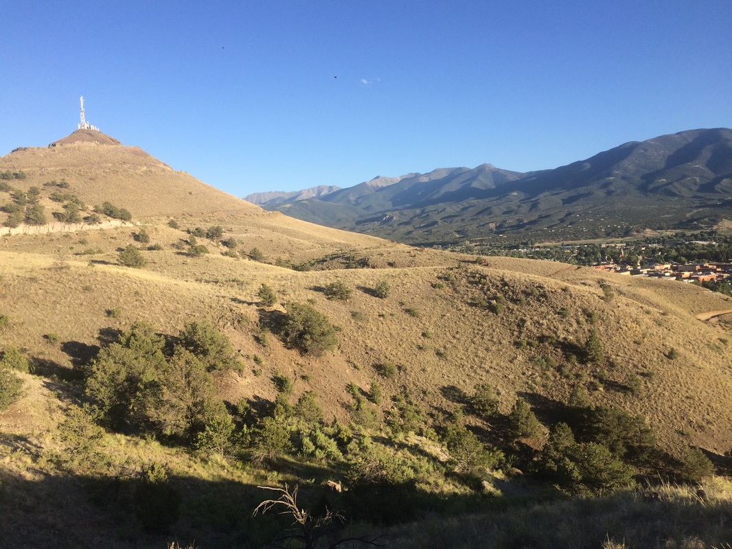 S-mountain left, Salida right including the eastern slopes of Methodist Mountain in partial view. 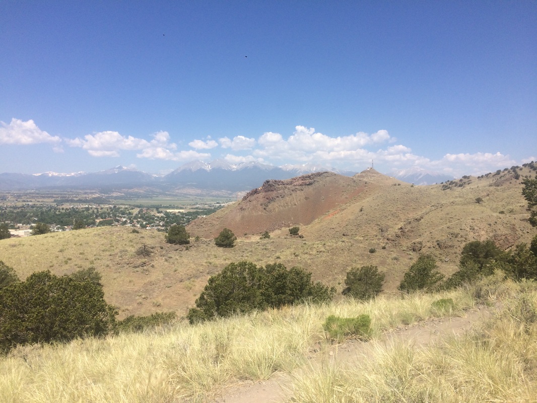 Mesa Trail in the foreground, cell phone towers center-right identify the top of S-Mountain and Salida is tucked under the green trees center-left. 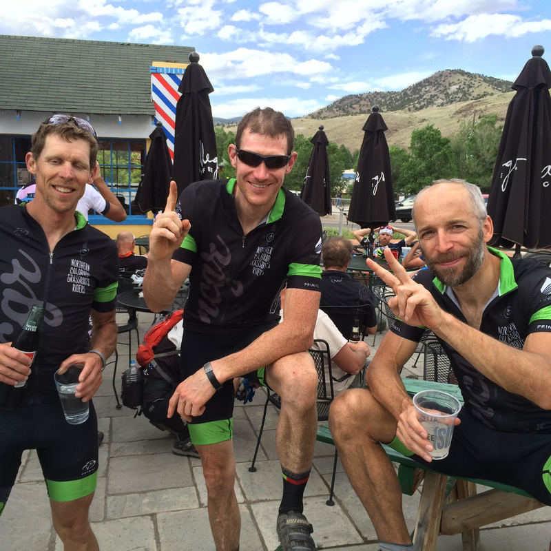 Celebrating a first and second place finish for Northern Colorado Grassroots Riders with my teammates (far left) Eric Swab and Ben Parman (1st overall). Comments are closed.
|
�
André BretonAdventure Guide, Mentor, Lifestyle Coach, Consultant, Endurance Athlete Categories
All
Archives
March 2021
|
 RSS Feed
Quick Links |
© COPYRIGHT 2021. ALL RIGHTS RESERVED.
|